ZMCK — ULAANBAATAR/Chinggis Khaan
ZMCK AD 2.1 Aerodrome location indicator and name
ZMCK — ULAANBAATAR/Chinggis Khaan
ZMCK AD 2.2 Aerodrome geographical and administrative data
| 1 | ARP coordinates and site at AD | 473849N 1064912E
105°, 1800m from THR 11 |
| 2 | Direction and distance from (city) | 194°, 31km (47km by road) from Ulaanbaatar downtown |
| 3 | Elevation/Reference temperature/Mean low temperature | 1367m / 24.4°C / -24.4°C |
| 4 | Geoid undulation at AD ELEV PSN | - |
| 5 | MAG VAR/Annual change | 5°W(2020) / 7.5'W |
| 6 | Name of AD operator, address, TEL and telefax numbers, e-mail address, AFS address and, if available, website address |
Chinggis khaan international airport Tel:976-71287300 Tel:976-71287373 Tel:976-71287777 AFS:ZMCKYDYX SITA:UBNCKXH Email:airportops@nubia-llc.mn |
| 7 | Types of traffic permitted (IFR/VFR) |
IFR / VFR |
| 8 | Remarks | NIL |
ZMCK AD 2.3 Operational hours
| 1 | Aerodrome operator |
H24 |
| 2 | Customs and immigration | H24 |
| 3 | Health and sanitation | H24 |
| 4 | AIS Briefing Office | H24 |
| 5 | ATS Reporting Office | H24 |
| 6 | MET Briefing Office | H24 |
| 7 | Air Traffic Service |
H24 |
| 8 | Fuelling | H24 |
| 9 | Handling | H24 |
| 10 | Security | H24 |
| 11 | De-icing | H24 |
| 12 | Remarks | NIL |
ZMCK AD 2.4 Handling services and facilities
| 1 | Cargo-handling facilities | Facilities handling weights up to 460t per day. |
| 2 | Fuel/oil types | TS-1 |
| 3 | Fuelling facilities/capacity | Jet fuel hydrant pit: 14pcs |
| 4 | De-icing facilities | De-icing vehicle: 1pc Location: 1. On TWY-F beside aircraft stand 7, 8, 9 2. On Apron behind aircraft stand 7, 8 Liquid: Glariant MP IV |
| 5 | Hangar space for visiting aircraft |
Will provide a limited service depending on type of aircraft. |
| 6 | Repair facilities for visiting aircraft | Repair facilities are available. |
| 7 | Remarks |
For more information on aircraft fuelling, please contact the following address: Tel:976-71287902 Tel:976-99099564 Email:ckjetfuel@mcaa.gov.mn |
ZMCK AD 2.5 Passenger facilities
| 1 | Hotels | In Ulaanbaatar and Zuunmod downtown |
| 2 | Restaurants | At AD and in downtown. |
| 3 | Transportation | Bus, taxi |
| 4 | Medical facilities | First aid at AD. Hospitals in downtown |
| 5 | Bank and post office | At AD. |
| 6 | Tourist Office |
- |
| 7 | Remarks |
NIL |
ZMCK AD 2.6 Rescue and fire fighting services
| 1 | AD category for fire fighting | CAT 9 |
| 2 | Rescue equipment | Fire fighting truck - 3pcs Water-capacity: 34500L Foam-capacity: 6000L/min Foam dispensing: 18000L/min Dry chemical substance: 750kg First aid vehicle - 1pc Mobile command vehicle - 1pc |
| 3 | Capability for removal of disabled aircraft |
It is regulated by the cooperation contract with the air carrier. |
| 4 | Remarks | The performance of the firefighting truck was calculated for 3 vehicles. |
ZMCK AD 2.7 Seasonal availability-clearing
| 1 | Types of clearing equipment | Snow removal vehicle: 8 truck |
| 2 | Clearance priorities | RWY, TWY, Apron |
| 3 | Remarks | NIL |
ZMCK AD 2.8 Aprons, taxiways and check locations/positions data
| 1 | Apron designation, surface and strength | Apron - concrete, PCN 86/R/B/X/T - asphalt, PCN 21/F/C/Y/T Hangar apron 1 - concrete, PCN 40/R/B/X/T |
| 2 | Taxiway designation, width, surface and strength | A, E - 29m, concrete, PCN 86/R/B/X/T B, C, D, F - 23m, concrete, PCN 86/R/B/X/T F1 - 32m, asphalt, PCN 43/F/C/X/T |
| 3 | Altimeter checkpoint location and elevation | Location / Elevation: At Apron / 1369m |
| 4 | VOR checkpoints | - |
| 5 | INS checkpoints | - |
| 6 | Remarks | NIL |
ZMCK AD 2.9 Surface movement guidance and control system and markings
| 1 | Use of aircraft stand ID signs, TWY guide lines and visual docking/parking guidance system of aircraft stands | Aircraft stand ID signs: 1-4, 6, 6a, 6b, 7-9, 21-30 (Refer to Aircraft Parking Chart) TWY Guidance lines: Available Visual docking |
| 2 | RWY and TWY markings and LGT | RWY markings: Transverse stripe, pre-THR, THR, designation, TDZ, aiming point, centre line, edge RWY lights: THR, centre line, edge, endTWY markings: Centre line, edge, holding position TWY lignts: Edge |
| 3 | Stop bars and RWY guard lights | Stop bars: NIL RWY guard lights: Available |
| 4 | Other markings | Apron safety line; Separation line of asphalt and concrete pavement of apron; Holding positions, guidance, parking and other markings of technical and service road on apron. |
| 5 | Remarks | NIL |
ZMCK AD 2.10 Aerodrome obstacles
1. Area 2 obstacles
For Area 2 obstacles, please use the following link:
https://ais.mn/files/aip/eAIP/AREA2/ZMCKAREA2_0821.pdf
2. Area 3 obstacles
For Area 3 obstacles, please use the following link:
https://ais.mn/files/aip/eAIP/AREA3/ZMCKAREA3_0821.pdf
ZMCK AD 2.11 Meteorological information provided
| 1 | Associated MET Office | Aviation Meteorological Centre |
| 2 | Hours of service MET Office outside hours |
H24 |
| 3 | Office responsible for TAF preparation Periods of validity |
Aviation Meteorological Centre 9, 30h |
| 4 | Trend forecast Interval of issuance |
TREND |
| 5 | Briefing/consultation provided | Personal consultation, telephone, closed circuit television, web: www.amc.namem.gov.mn, other device, self-briefing display |
| 6 | Flight documentation Language(s) used |
Charts, tabular forms, abbreviated plain language text Mongolian, English |
| 7 | Charts and other information available for briefing or consultation | Surface and upper air analysis charts, prognostic charts, significant weather charts, upper winds/temperatures charts, |
| 8 | Supplementary equipment available for providing information | Doppler radar of weather, satellite data, products of world area forecast system |
| 9 | ATS units provided with information | TWR, APP, ACC |
| 10 | Climatological information | Climatology |
| 11 | Additional information (limitation of service, etc.) | AD, route, landing and take-off forecasts, AIRMET, SIGMET, AD WRNG
Tel:976-71285024 Tel:976-71287260 Tel:976-71287279 |
ZMCK AD 2.12 Runway physical characteristics
| Designator RWY NR |
TRUE BRG |
Dimensions of RWY(m) |
Strength (PCN) and surface of RWY and SWY | THR coordinates RWY end coordinates THR geoid undulation |
THR elevation and highest elevation of TDZ of precision APP RWY | Slope of RWY-SWY |
|---|---|---|---|---|---|---|
| 1 | 2 | 3 | 4 | 5 | 6 | 7 |
11 |
104.63° |
3600 x 45 |
PCN 86/R/B/X/T concrete |
473903.63N 1064748.22E |
THR: 1367m |
RWY: 0.04% |
29 |
284.67° |
3600 x 45 |
PCN 86/R/B/X/T concrete |
473834.15N 1065035.10E |
THR: 1366m |
RWY: 0.04% |
| SWY dimensions (m) |
CWY dimensions (m) | Strip dimensions (m) | RESA (m) | Location and description of arresting system | OFZ | Remarks |
|---|---|---|---|---|---|---|
| 8 | 9 | 10 | 11 | 12 | 13 | 14 |
| - | - | 3720 x 300 |
240 х 90 |
- | - | NIL |
| - | - | 3720 x 300 |
180 х 90 |
- | - | NIL |
ZMCK AD 2.13 Declared distances
| RWY NR | TORA (m) | TODA (m) | ASDA (m) | LDA (m) |
Remarks |
|---|---|---|---|---|---|
| 1 | 2 | 3 | 4 | 5 | 6 |
11 |
3600 |
3600 |
3600 |
3600 |
NIL |
29 |
3600 |
3600 |
3600 |
3600 |
NIL |
ZMCK AD 2.14 Approach and runway lighting
| RWY Designator |
APCH LGT, Type, LEN, INTST |
THR LGT, colour, WBAR |
VASIS (MEHT) PAPI |
TDZ, LGT LEN |
|---|---|---|---|---|
| 1 | 2 | 3 | 4 | 5 |
11 |
SALS 420m LIH |
green |
PAPI 3° Left (20.7m) |
- |
29 |
PALS CAT I 900m LIH |
green |
PAPI 3° Left (20.7m) |
- |
| RWY Centre Line LGT LEN, spacing, colour, INTST |
RWY edge LGT LEN, spacing, colour, INTST |
RWY End LGT colour WBAR |
SWY LGT LEN colour |
Remarks |
|---|---|---|---|---|
| 6 | 7 | 8 | 9 | 10 |
3600m, 30m LIH |
3600m 60m white yellow LIH |
red |
Refer to AD Chart | |
3600m, 30m LIH |
3600m 60m white yellow LIH |
red |
Refer to AD Chart |
ZMCK AD 2.15 Other lighting, secondary power supply
| 1 | ABN/IBN location, characteristics and operational hours | Control tower signalling beacon: At Tower Building, white/green |
| 2 | LDI location and LGT Anemometer location and LGT |
Anemometer: LGTD, 340m from THR 11 |
| 3 | TWY edge and centre line lighting | Edge: TWY - A, B, C, D, E, F, F1 Centre line: - |
| 4 | Secondary power supply/switch-over time | Secondary power supply to all lighting at AD. |
| 5 | Remarks | NIL |
ZMCK AD 2.16 Helicopter landing area
| 1 | Coordinates TLOF or THR of FATO Geoid undulation |
- |
| 2 | TLOF and/or FATO elevatiosn (m) | - |
| 3 | TLOF and FATO area dimensions, surface, strength, marking | - |
| 4 | True BRG of FATO | - |
| 5 | Declared distance available | - |
| 6 | APP and FATO lighting | - |
| 7 | Remarks | Use RWY |
ZMCK AD 2.17 ATS airspace
| 1 | Designation and lateral limits | ULAANBAATAR CTR 473341N 1063044E -
474645N 1063544E -
474117N 1070641E -
472814N 1070134E -
473341N 1063044E |
| 2 | Vertical limits |
GND-2100m |
| 3 | Airspace classification | C |
| 4 | ATS unit call sign Language(s) |
Ulaanbaatar tower Mongolian and English |
| 5 | Transition altitude |
3000m 3300m (QNH≥1031hPa) |
| 6 | Remarks |
NIL |
ZMCK AD 2.18 ATS communication facilities
| Service designation |
Call sign |
Frequency |
Hours of operation |
Remarks |
|---|---|---|---|---|
| 1 | 2 | 3 | 4 | 5 |
APP |
Ulaanbaatar approach |
120MHz |
H24 |
|
TWR |
Ulaanbaatar tower |
129MHz |
H24 |
|
FIS |
Artsat |
5715kHz |
H24 |
2435kHz (HN) |
Tuul |
5505kHz |
H24 |
2435kHz (HN) |
|
SAR |
UBRCC |
121.5MHz 5680kHz |
H24 |
|
ATIS |
Chinggis Khaan INFO | 123.7MHz |
H24 |
ZMCK AD 2.19 Radio navigation and landing aids
| Type of aid, MAG VAR, CAT of ILS/MLS (For VOR/ILS/MLS, give declination) |
ID |
Frequency |
Hours of operation |
Position of transmitting antenna coordinates |
Elevation of DME transmitting antenna |
Remarks |
|---|---|---|---|---|---|---|
| 1 | 2 | 3 | 4 | 5 | 6 | 7 |
VOR/DME (5°W/2020) |
SER |
116.9MHz 1203MHz CH 116X |
H24 |
473841.1N 1064908.7E |
1380m | VOR/DME unusable: RDL 340°-070° (clockwise), beyond 25 NM below 3800m AMSL. |
ILS 29 (5°W/2020) LOC |
CDA |
109.9MHz |
H24 |
473906.1N 1064734.3E |
LOC: 300m away FM RWY 11 BRG (MAG) 289° |
|
ILS 29 (5°W/2020) GP |
- | 333.8MHz |
H24 |
473832.9N 1065019.5E |
GP: 327m inside FM RWY THR, 120m S of RCLGP angle 3.0° |
|
ILS/DME |
CDA |
997MHz 1060MHz (CH 36X) |
H24 |
473832.9N 1065019.5E |
1380m |
ILS/DME: 327m inside FM RWY THR |
ZMCK AD 2.20 Local aerodrome regulations
NIL
ZMCK AD 2.21 Noise abatement procedures
NIL
ZMCK AD 2.22 Flight procedures
1. Visual flight procedure
2. Instrument flight procedure
-
ENR 1.1, ENR 1.3 and ENR 1.7;
-
Standard Departure Charts contained in AD 2-ZMCK-9-1, AD 2-ZMCK-9-3, AD 2-ZMCK-9-5, AD 2-ZMCK-9-7 AD 2-ZMCK-9-9, AD 2-ZMCK-9-11, AD 2-ZMCK-9-13, AD 2-ZMCK-9-15, AD 2-ZMCK-9-17 AD 2-ZMCK-9-19 and AD 2-ZMCK-9-21;
-
Standard Arrival Charts contained in AD 2-ZMCK-11-1, AD 2-ZMCK-11-3, AD 2-ZMCK-11-5, AD 2-ZMCK-11-7 and AD 2-ZMCK-11-9;
-
Instrument Approach Charts contained in AD 2-ZMCK-13-1, AD 2-ZMCK-13-3, AD 2-ZMCK-13-5, AD 2-ZMCK-13-7, AD 2-ZMCK-13-9, AD 2-ZMCK-13-11, AD 2-ZMCK-13-13, AD 2-ZMCK-13-15, AD 2-ZMCK-13-17, AD 2-ZMCK-13-19, AD 2-ZMCK-13-21 and AD 2-ZMCK-13-23.
ZMCK AD 2.23 Additional information
1. Fuel dumping area
Information concerning the fuel dumping area of Chinggis Khaan international airport is shown below.

2. Bird concentration in the vicinity of aerodrome
The airport is located near a lake and a small river on the border of the Khentii mountainous region and steppe zone, so in addition to steppe and wetland birds, forest and water birds can be found during migration. There are 83 common bird species, 73% of which are migratory.
Birds at risk of endangering aircraft such as red-billed chough, cinereous vulture, demoiselle crane, upland buzzard, ruddy shelduck, black kite and whooper swan.
Table-1. Information on high-risk birds in the vicinity of aerodrome at Chinggis Khaan international airport
| № | Name of the bird |
Weight (gram) |
Flight height (meter) |
Average density of birds per 1km square in the bird concentrations area |
Habitat |
|---|---|---|---|---|---|
| 1 | Red-billed chough |
280-430 | 1-100 | 1.2 | Steppe, town |
| 2 | Cinereous vulture |
7500-12000 | 1-1000 | 0.01 | Steppe, high mountain |
| 3 | Demoiselle crane |
2000-3000 | 1-100 | 0.051 | Steppe, wetland area |
| 4 | Upland buzzard |
1000-1300 | 1-200 | 0.153 | Steppe, wetland area |
| 5 | Ruddy shelduck |
900-1600 | 1-300 | 3.98 | Wetland area, river valley /stream/ |
| 6 | Black kite |
800-1100 | 1-400 | 0.05 | Steppe, butchery, wastewater pond, town |
| 7 | Whooper swan |
10000-12000 | 1-100 | 2.9 | Wetland area, river valley /stream/ |
Table-2. Length of stay of high-risk birds in the vicinity of aerodrome at Chinggis Khaan international airport

Graphic-1. Average flight height of high-risk birds in the vicinity of aerodrome at Chinggis Khaan international airport (meter)
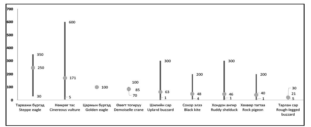
Following birds flew relatively high such as cinereous vulture, steppe eagle, golden eagle, demoiselle crane, upland buzzard, black kite, ruddy shelduck and rock pigeon.
The location with bird concentration near the terminal areas are illustrated in chart AD 2-ZMCK-15-1 "Bird concentrations in the vicinity of aerodrome"
ZMCK AD 2.24 Charts related to aerodromes
| Хуудас/Page |
|
|---|---|
Aerodrome Chart-ICAO |
AD 2-ZMCK-2-1 |
Aerodrome Chart-ICAO |
AD 2-ZMCK-2-2 |
Aircraft Parking Chart-ICAO |
AD 2-ZMCK-3-1 |
Aircraft Parking Chart-ICAO |
AD 2-ZMCK-3-2 |
Standard Departure Chart-Instrument (SID)-ICAO (RWY 11/29 ANIKU 1A/1B) |
AD 2-ZMCK-9-1 |
Conversion table (SID)-ICAO (RWY 11/29 ANIKU 1A/1B) |
AD 2-ZMCK-9-2 |
Standard Departure Chart-Instrument (SID)-ICAO (RWY 11/29 MODOT 1A/1B) |
AD 2-ZMCK-9-3 |
Conversion table (SID)-ICAO (RWY 11/29 MODOT 1A/1B) |
AD 2-ZMCK-9-4 |
Standard Departure Chart-Instrument (SID)-ICAO (RWY 11/29 POMAZ 1A/1B) |
AD 2-ZMCK-9-5 |
Conversion table (SID)-ICAO (RWY 11/29 POMAZ 1A/1B) |
AD 2-ZMCK-9-6 |
Standard Departure Chart-Instrument (SID)-ICAO (RWY 11/29 VIZOT 1A/1B) |
AD 2-ZMCK-9-7 |
Conversion table (SID)-ICAO (RWY 11/29 VIZOT 1A/1B) |
AD 2-ZMCK-9-8 |
Standard Departure Chart-Instrument (SID)-ICAO (RWY 11 BUGAN 1B) |
AD 2-ZMCK-9-9 |
AeronauticalData Tabulation (SID)-ICAO (RWY 11 BUGAN 1B) |
AD 2-ZMCK-9-10 |
Standard Departure Chart-Instrument (SID)-ICAO (RNAV(GNSS) RWY 11/29 ANIKU 1C/1D) |
AD 2-ZMCK-9-11 |
Aeronautical Data Tabulation (SID)-ICAO (RNAV(GNSS) RWY 11/29 ANIKU 1C/1D) |
AD 2-ZMCK-9-12 |
Standard Departure Chart-Instrument (SID)-ICAO (RNAV(GNSS) RWY 11/29 MODOT 1C/2D) |
AD 2-ZMCK-9-13 |
Aeronautical Data Tabulation (SID)-ICAO (RNAV(GNSS) RWY 11/29 MODOT 1C/2D) |
AD 2-ZMCK-9-14 |
Standard Departure Chart-Instrument (SID)-ICAO (RNAV(GNSS) RWY 11/29 POMAZ 1C/1D) |
AD 2-ZMCK-9-15 |
Aeronautical Data Tabulation (SID)-ICAO (RNAV(GNSS) RWY 11/29 POMAZ 1C/1D) |
AD 2-ZMCK-9-16 |
Standard Departure Chart-Instrument (SID)-ICAO (RNAV(GNSS) RWY 11/29 VIZOT 1C/1D) |
AD 2-ZMCK-9-17 |
Aeronautical Data Tabulation (SID)-ICAO (RNAV(GNSS) RWY 11/29 VIZOT 1C/1D) |
AD 2-ZMCK-9-18 |
Standard Departure Chart-Instrument (SID)-ICAO (RNAV(GNSS) RWY 11 BUGAN 1D) |
AD 2-ZMCK-9-19 |
Aeronautical Data Tabulation (SID)-ICAO (RNAV(GNSS) RWY 11 BUGAN 1D) |
AD 2-ZMCK-9-20 |
Standard Departure Chart-Instrument (SID)-ICAO (RNAV(GNSS) RWY 11/29 SANOT 1C/1D) |
AD 2-ZMCK-9-21 |
Aeronautical Data Tabulation (SID)-ICAO (RNAV(GNSS) RWY 11/29 SANOT 1C/1D) |
AD 2-ZMCK-9-22 |
Standard Arrival Chart-Instrument (STAR)-ICAO (RWY 11 MODOT 1X, ANIKU 1X, VIZOT 1X, BUGAN 1X) |
AD 2-ZMCK-11-1 |
Conversion table (STAR)-ICAO (RWY 11 MODOT 1X, ANIKU 1X, VIZOT 1X, BUGAN 1X) |
AD 2-ZMCK-11-2 |
Standard Arrival Chart-Instrument (STAR)-ICAO (RWY 29 MODOT 1Z, ANIKU 1Z, VIZOT 1Y) |
AD 2-ZMCK-11-3 |
Conversion table (STAR)-ICAO (RWY 29 MODOT 1Z, ANIKU 1Z, VIZOT 1Y) |
AD 2-ZMCK-11-4 |
Standard Arrival Chart-Instrument (STAR)-ICAO (RNAV(GNSS) RWY 29 VIZOT 1Z, BUGAN 1Z) |
AD 2-ZMCK-11-5 |
Conversion table (STAR)-ICAO (RNAV(GNSS) RWY 29 VIZOT 1Z, BUGAN 1Z) |
AD 2-ZMCK-11-6 |
Standard Arrival Chart-Instrument (STAR)-ICAO (RNAV(GNSS) RWY 11 MODOT 1V, ANIKU 1V, VIZOT 1V, BUGAN 1V) |
AD 2-ZMCK-11-7 |
Conversion table (STAR)-ICAO (RNAV(GNSS) RWY 11 MODOT 1V, ANIKU 1V, VIZOT 1V, BUGAN 1V) |
AD 2-ZMCK-11-8 |
Standard Arrival Chart-Instrument (STAR)-ICAO (RNAV(GNSS) RWY 29 ANIKU 1W, VIZOT 1W, SANOT 1W, BUGAN 1W) |
AD 2-ZMCK-11-9 |
Conversion table (STAR)-ICAO (RNAV(GNSS) RWY 29 ANIKU 1W, VIZOT 1W, SANOT 1W, BUGAN 1W) |
AD 2-ZMCK-11-10 |
Instrument Approach Chart-ICAO (VOR Z RWY 11 ACFT CAT A/B, C/D) |
AD 2-ZMCK-13-1 |
Conversion table (VOR Z RWY 11 ACFT CAT A/B, C/D) |
AD 2-ZMCK-13-2 |
Instrument Approach Chart-ICAO (VOR Z RWY 29 ACFT CAT A/B, C/D) |
AD 2-ZMCK-13-3 |
Conversion table (VOR Z RWY 29 ACFT CAT A/B, C/D) |
AD 2-ZMCK-13-4 |
Instrument Approach Chart-ICAO (VOR Y RWY 11 ACFT CAT A/B, C/D) |
AD 2-ZMCK-13-5 |
Conversion table (VOR Y RWY 11 ACFT CAT A/B, C/D) |
AD 2-ZMCK-13-6 |
Instrument Approach Chart-ICAO (VOR Y RWY 29 ACFT CAT A/B, C/D) |
AD 2-ZMCK-13-7 |
Conversion table (VOR Y RWY 29 ACFT CAT A/B, C/D) |
AD 2-ZMCK-13-8 |
Instrument Approach Chart-ICAO (ILS Z RWY 29 ACFT CAT A/B, C/D) |
AD 2-ZMCK-13-9 |
Conversion table (ILS Z RWY 29 ACFT CAT A/B, C/D) |
AD 2-ZMCK-13-10 |
Instrument Approach Chart-ICAO (ILS Y RWY 29 ACFT CAT A/B, C/D) |
AD 2-ZMCK-13-11 |
Conversion table (ILS Y RWY 29 ACFT CAT A/B, C/D) |
AD 2-ZMCK-13-12 |
Instrument Approach Chart-ICAO (ILS X RWY 29 ACFT CAT A/B, C/D) |
AD 2-ZMCK-13-13 |
Aeronautical Data Tabulation (ILS X RWY 29 ACFT CAT A/B, C/D) |
AD 2-ZMCK-13-14 |
Instrument Approach Chart-ICAO (LOC Z RWY 29 ACFT CAT A/B, C/D) |
AD 2-ZMCK-13-15 |
Conversion table (LOC Z RWY 29 ACFT CAT A/B, C/D) |
AD 2-ZMCK-13-16 |
Instrument Approach Chart-ICAO (LOC Y RWY 29 ACFT CAT A/B, C/D) |
AD 2-ZMCK-13-17 |
Conversion table (LOC Y RWY 29 ACFT CAT A/B, C/D) |
AD 2-ZMCK-13-18 |
Instrument Approach Chart-ICAO (LOC X RWY 29 ACFT CAT A/B, C/D) |
AD 2-ZMCK-13-19 |
Aeronautical Data Tabulation (LOC X RWY 29 ACFT CAT A/B, C/D) |
AD 2-ZMCK-13-20 |
Instrument Approach Chart-ICAO (RNP RWY 11 (LNAV only) ACFT CAT A/B, C/D) |
AD 2-ZMCK-13-21 |
Aeronautical Data Tabulation (RNP RWY 11 (LNAV only) ACFT CAT A/B, C/D) |
AD 2-ZMCK-13-22 |
Instrument Approach Chart-ICAO (RNP RWY 29 (LNAV only) ACFT CAT A/B, C/D) |
AD 2-ZMCK-13-23 |
Aeronautical Data Tabulation (RNP RWY 29 (LNAV only) ACFT CAT A/B, C/D) |
AD 2-ZMCK-13-24 |
Bird concentrations in the vicinity of aerodrome |
AD 2-ZMCK-15-1 |