GEN 3.2 Aeronautical charts
1. Responsible service
2. Maintenance of charts
3. Purchase arrangements
Aeronautical Information Services Division
Buyant-Ukhaa International Airport
P.O.Box-59
Ulaanbaatar 17120
Mongolia
Tel:976-71283065
Fax:976-70049838
AFS:ZMUBYOYX
SITA:ULNNTOM
Email:chart@mcaa.gov.mn
Web:www.ais.mn
Note: The operational hours are MON-FRI: 00:00-09:00 UTC.
4. Aeronautical chart series available
Aerodrome chart - ICAO;
Aircraft Parking Chart - ICAO;
Enroute Chart - ICAO;
Standard Departure Chart - Instrument (SID) - ICAO;
Standard Arrival Chart – instrument (STAR) – ICAO;
Instrument Approach Chart – ICAO (for each runway and procedure type);
Visual Approach Chart - ICAO;
Bird concentrations in the vicinity of aerodrome;
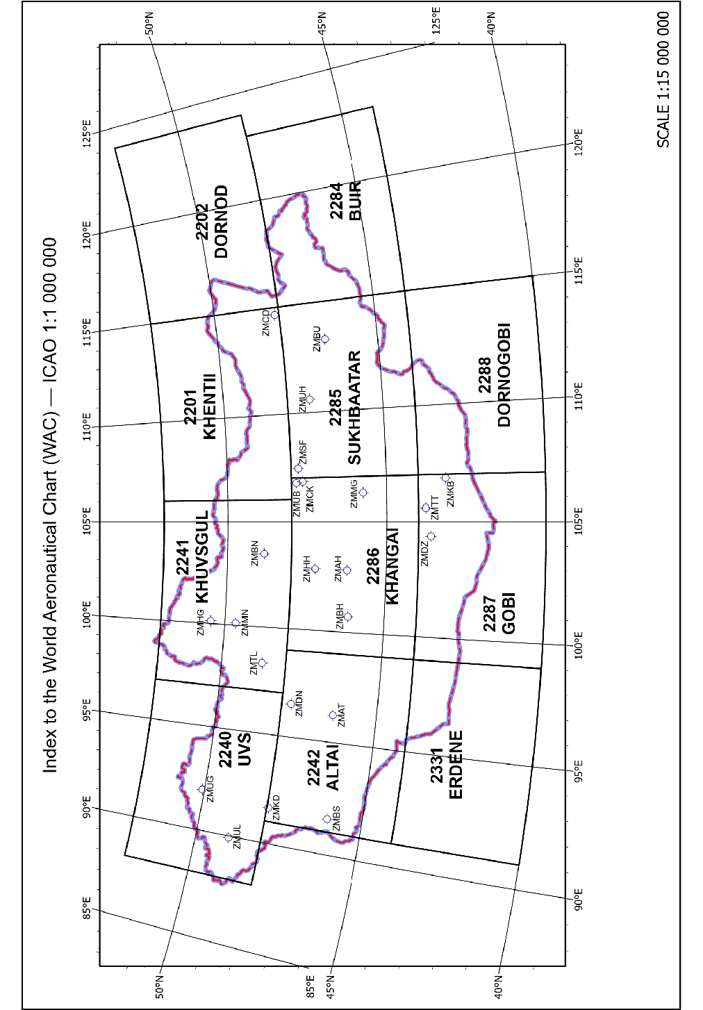
World Aeronautical Chart (WAC) - ICAO 1:1000000;
Aeronautical Chart – ICAO 1:500000.
Note: “Aerodrome Obstacle Chart - ICAO Type A” is not published for Chinggis Khaan International Airport and Buyant-Ukhaa International Airport because no obstacles exist in the take-off flight path area.
The charts currently available are listed under GEN 3.2.5.
Aerodrome Chart - ICAO
This chart contains detailed aerodrome/heliport data to provide flight crew with information that will facilitate the ground movement of aircraft:
from the aircraft stand to the runway; and
from the runway to the aircraft stand.
Aircraft Parking Chart - ICAO
This chart is produced for those aerodromes where, due to the complexity of the terminal facilities, the information to facilitate the ground movement of aircraft between the taxiways and the aircraft stands and the parking/docking of aircraft cannot be shown with sufficient clarity on the Aerodrome/Heliport Chart — ICAO or on the Aerodrome Ground Movement Chart — ICAO.
Enroute Chart - ICAO
This chart is produced for the entire Ulaanbaatar FIR. The aeronautical data include all aerodromes and the air traffic services system in detail. This chart provides the flight crews with information to facilitate navigation along ATS routes in compliance with air traffic services procedures.
Standard Departure Chart - Instrument (SID) - ICAO
This chart is produced whenever a standard departure route - instrument has been established and cannot be shown with sufficient clarity on the Enroute Chart - ICAO. This chart provides the flight crew with the designated standard departure route instrument from the take-off phase to the en-route phase.
Standard Arrival Chart — Instrument (STAR) - ICAO
This chart is produced whenever a standard arrival route —instrument has been established and cannot be shown with sufficient clarity on the Enroute Chart — ICAO. This chart provides the flight crew with information that will enable them to comply with the designated standard arrival route - instrument from the en-route phase to the approach phase.
Instrument Approach Chart - ICAO
This chart shall provide flight crews with information which will enable them to perform an approved instrument approach procedure to the runway of intended landing including the missed approach procedure and, where applicable, associated holding patterns. Instrument Approach Charts-ICAO shall be made available for all aerodromes used by international civil aviation where instrument approach procedures have been established by the State concerned.
Visual Approach Chart - ICAO
This chart shall provide flight crews with information which will enable them to transit from the en-route/descent to approach phases of flight to the runway of intended landing by means of visual reference.
Bird concentrations in the vicinity of aerodrome
This chart provides information of bird concentration recorded in the approach zone of an aerodrome.
World Aeronautical Chart (WAC) - ICAO 1:1000000
This chart shall provide information to satisfy the requirements of visual air navigation.
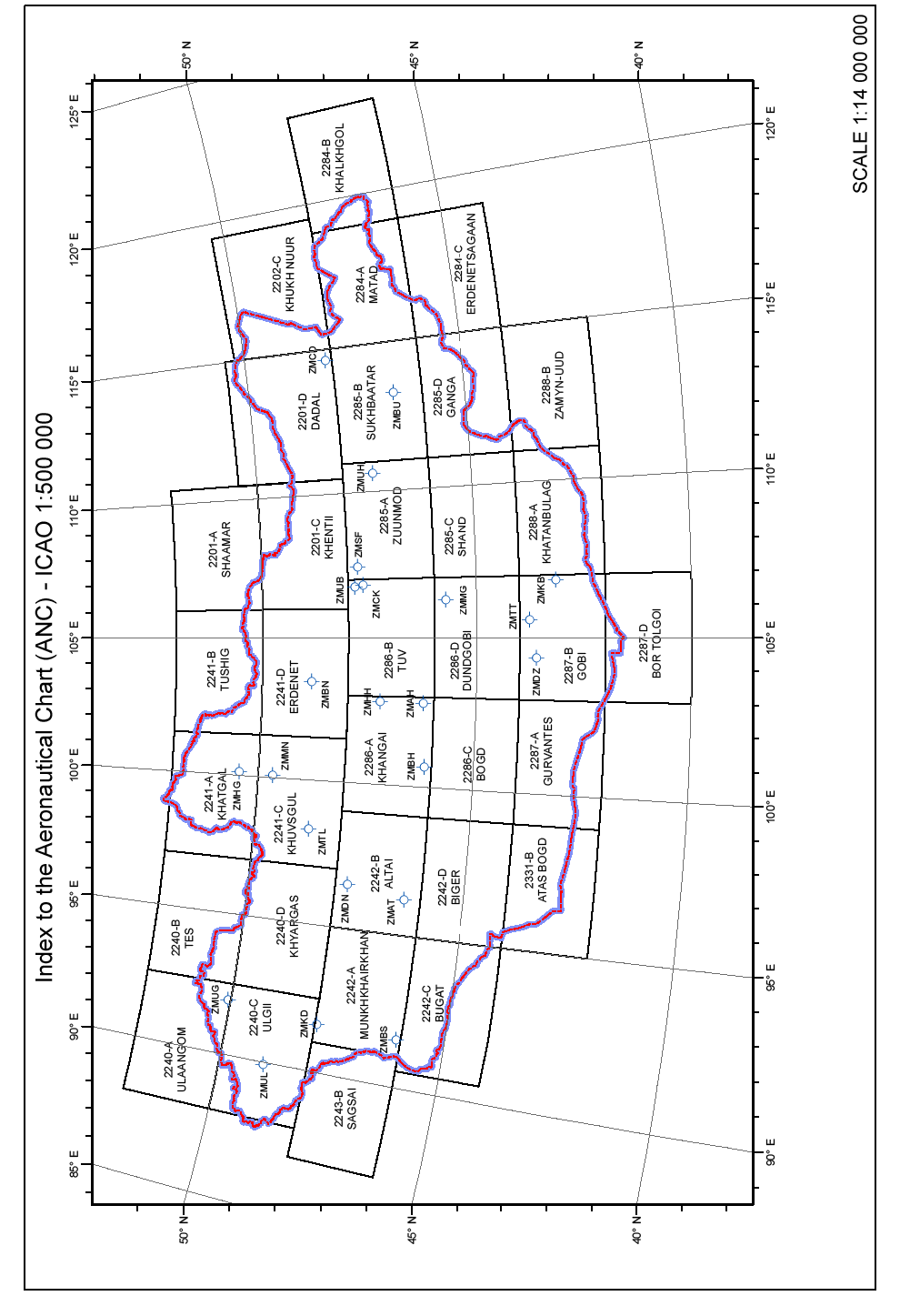
Aeronautical Chart – ICAO 1:500000
This chart shall provide information to satisfy the requirements of visual air navigation for low speed, short- or medium-range operations at low and intermediate altitudes.
5. List of aeronautical charts available
| № |
Title of series |
Scale |
Name and/or number | Unit price |
Date of latest revision |
|---|---|---|---|---|---|
| 1 |
Enroute-chart - ICAO | 1:3000000 |
Upper/Lower airspace | MNT 56400 |
10 SEP 2020 |
| 2 |
World Aeronautical Chart - ICAO | 1:1000000 |
- 2240 UVS |
MNT 28200 | 31 DEC 2020 |
|
- 2241 KHUVSGUL | 31 DEC 2020 | ||||
|
- 2201 KHENTII | 31 DEC 2020 | ||||
|
- 2202 DORNOD | 31 DEC 2020 | ||||
|
- 2242 ALTAI | 31 DEC 2020 | ||||
|
- 2286 KHANGAI | 31 DEC 2020 | ||||
|
- 2285 SUKHBAATAR | 31 DEC 2020 | ||||
|
- 2284 BUIR | 31 DEC 2020 | ||||
|
- 2331 ERDENE | 31 DEC 2020 | ||||
|
- 2287 GOBI | 17 JUN 2021 | ||||
|
- 2288 DORNOGOBI | 31 DEC 2020 | ||||
| 3 |
Aeronautical Chart – ICAO | 1:500000 |
2201-A SHAAMAR |
MNT 28200 | 26 AUG 2021 |
|
2201-C KHENTII | 26 AUG 2021 | ||||
|
2201-D DADAL | 26 AUG 2021 | ||||
|
2202-C KHUKH NUUR | 26 AUG 2021 | ||||
|
2240-A ULAANGOM | 26 AUG 2021 | ||||
|
2240-B TES | 26 AUG 2021 | ||||
|
2240-C ULGII | 26 AUG 2021 | ||||
|
2240-D KHYARGAS | 26 AUG 2021 | ||||
|
2241-A KHATGAL | 26 AUG 2021 | ||||
|
2241-B TUSHIG | 26 AUG 2021 | ||||
|
2241-C KHUVSGUL | 26 AUG 2021 | ||||
|
2241-D ERDENET | 26 AUG 2021 | ||||
| 2242-A MUNKHKHAIRKHAN | 26 AUG 2021 | ||||
|
2242-B ALTAI | 26 AUG 2021 | ||||
|
2242-C BUGAT | 26 AUG 2021 | ||||
|
2242-D BIGER | 26 AUG 2021 | ||||
|
2243-B SAGSAI | 26 AUG 2021 | ||||
|
2284-A MATAD | 26 AUG 2021 | ||||
|
2284-B KHALKHGOL | 26 AUG 2021 | ||||
|
2284-C ERDENETSAGAAN | 26 AUG 2021 | ||||
|
2285-A ZUUN MOD | 26 AUG 2021 | ||||
|
2285-B SUKHBAATAR | 26 AUG 2021 | ||||
|
2285-C SHAND | 26 AUG 2021 | ||||
|
2285-D GANGA | 26 AUG 2021 | ||||
|
2286-A KHANGAI | 26 AUG 2021 | ||||
|
2286-B TUV | 26 AUG 2021 | ||||
|
2286-C BOGD | 26 AUG 2021 | ||||
|
2286-D DUNDGOBI | 26 AUG 2021 | ||||
|
2287-A GURVANTES | 26 AUG 2021 | ||||
|
2287-B GOBI | 26 AUG 2021 | ||||
|
2287-D BOR TOLGOI | 26 AUG 2021 | ||||
|
2288-A KHATANBULAG | 26 AUG 2021 | ||||
|
2288-B ZAMYN-UUD | 26 AUG 2021 | ||||
|
2331-B ATAS BOGD | 26 AUG 2021 |
Note: Value Added Tax (VAT) is applicable.
|
№ |
Aerodrome name/locationindicator |
Title of series and name of chart |
Scale |
Date of latest revision |
|---|---|---|---|---|
|
1 |
Arvaikheer/ZMAH |
Aerodrome Chart - ICAO |
1:16000 |
REF to AIP page |
|
2 |
Altai/ZMAT |
Aerodrome Chart - ICAO |
1:15000 | |
|
Standard Departure Chart - Instrument (SID) -ICAO - RWY 10 BH 1A, DULAN 1A, DONOI 1A ACFT CAT B/C |
1:780000 | |||
|
Instrument Approach Chart - ICAO - VOR Z RWY 28 ACFT CAT B - VOR Y RWY 28 ACFT CAT B/C - RNP RWY 28 (LNAV only) ACFT CAT B/C |
1:390000 1:390000 1:390000 | |||
|
Bird concentrations in the vicinity of aerodrome |
1:200000 | |||
|
3 |
Bayankhongor/ZMBH |
Aerodrome Chart - ICAO |
1:16000 | |
|
4 |
Bulgan/ZMBN |
Aerodrome Chart - ICAO |
1:12000 | |
|
5 |
Bulgan sum/ZMBS |
Aerodrome Chart - ICAO |
1:10000 | |
|
6 |
Baruun-Urt/ZMBU |
Aerodrome Chart - ICAO |
1:13000 | |
|
7 |
Choibalsan/ZMCD |
Aerodrome Chart - ICAO |
1:18000 | |
|
Standard Departure Chart - Instrument (SID) -ICAO - OMNIDIRECTIONAL DEPARTURE RWY 12/30 ACFT CAT A/B/C |
1:220000 | |||
|
Instrument Approach Chart – ICAO - NDB RWY 12 ACFT CAT A/B - NDB RWY 12 ACFT CAT C - NDB Z RWY 30 ACFT CAT A/B - NDB Z RWY 30 ACFT CAT C - NDB Y RWY 30 ACFT CAT A/B, C - RNAV (GNSS) RWY 12 ACFT CAT A/B, C - RNAV (GNSS) RWY 30 ACFT CAT A/B, C |
1:220000 1:220000 1:220000 1:250000 1:220000 1:300000 1:300000 | |||
|
8 |
Chinggis khaan/ZMCK |
Aerodrome Chart - ICAO |
1:14000 | |
|
Aircraft Parking Chart - ICAO |
1:2200 | |||
|
Standard Departure Chart - Instrument (SID) -ICAO - RWY 11/29 ANIKU 1A/1B - RWY 11/29 MODOT 1A/1B - RWY 11/29 POMAZ 1A/1B - RWY 11/29 VIZOT 1A/1B - RWY 11 BUGAN 1B - RNAV(GNSS) RWY 11/29 ANIKU 1C/1D - RNAV(GNSS) RWY 11/29 MODOT 1C/2D - RNAV(GNSS) RWY 11/29 POMAZ 1C/1D - RNAV(GNSS) RWY 11/29 VIZOT 1C/1D - RNAV(GNSS) RWY 11 BUGAN 1D - RNAV(GNSS) RWY 11/29 SANOT 1C/1D |
1:530000 1:520000 1:520000 1:550000 1:590000 1:590000 1:520000 1:650000 1:650000 1:520000 1:650000 | |||
|
Standard Arrival Chart — Instrument (STAR) - ICAO - RWY 11 MODOT 1X, ANIKU 1X, VIZOT 1X, BUGAN 1X - RWY 29 MODOT 1Z, ANIKU 1Z, VIZOT 1Y - RWY 29 VIZOT 1Z, BUGAN 1Z - RNAV(GNSS) RWY 11 MODOT 1V, ANIKU 1V, VIZOT 1V, BUGAN 1V - RNAV(GNSS) RWY 29 ANIKU 1W, VIZOT 1W, BUGAN 1W |
1:650000 1:650000 1:650000 1:650000
1:650000 |
REF to AIP page | ||
|
Instrument Approach Chart – ICAO - VOR Z RWY 11 ACFT CAT A/B, C/D - VOR Z RWY 29 ACFT CAT A/B, C/D - VOR Y RWY 11 ACFT CAT A/B, C/D - VOR Y RWY 29 ACFT CAT A/B, C/D - ILS Z RWY 29 ACFT CAT A/B, C/D - ILS Y RWY 29 ACFT CAT A/B, C/D - ILS X RWY 29 ACFT CAT A/B, C/D - LOC Z RWY 29 ACFT CAT A/B, C/D - LOC Y RWY 29 ACFT CAT A/B, C/D - LOC X RWY 29 ACFT CAT A/B, C/D - RNP RWY 11 (LNAV only) ACFT CAT A/B, C/D - RNP RWY 29 (LNAV only) ACFT CAT A/B, C/D |
1:530000 1:440000 1:370000 1:370000 1:370000 1:370000 1:370000 1:370000 1:370000 1:370000 1:420000 1:370000 | |||
| Bird concentrations in the vicinity of aerodrome | 1:125000 | |||
|
9 |
Otgontenger/ZMDN |
Aerodrome Chart - ICAO |
1:17500 | |
|
10 |
Gurvansaikhan/ZMDZ |
Aerodrome Chart - ICAO |
1:15000 | |
|
Instrument Approach Chart – ICAO - NDB RWY 29 ACFT CAT A/B, C |
1:350000 | |||
|
11 |
Khatgal/ZMHG |
Aerodrome Chart - ICAO |
1:13000 | |
|
12 |
Kharkhorin/ZMHH |
Aerodrome Chart - ICAO |
1:10000 | |
|
13 |
Khanbumbat/ZMKB |
Aerodrome Chart - ICAO |
1:12000 | |
|
Instrument Approach Chart – ICAO - NDB RWY 16 ACFT CAT A/B,C/D - NDB RWY 34 ACFT CAT A/B,C/D |
1:340000 1:340000 | |||
|
14 |
Khovd/ZMKD |
Aerodrome Chart - ICAO |
1:16000 | |
|
Standard Departure Chart - Instrument (SID) -ICAO - RWY 16/34 BUREG 1A/1B ACFT CAT A/B/C - RWY 16/34 DAVST 1A/1B ACFT CAT A/B/C - RWY 16/34 HARUS 1A/1B ACFT CAT A/B/C |
1:500000 1:500000 1:500000 | |||
|
Instrument Approach Chart – ICAO - NDB RWY 34 ACFT CAT A/B - NDB RWY 34 ACFT CAT C/D - RNAV (GNSS) RWY 34 ACFT CAT A/B/C |
1:240000 1:260000 1:370000 | |||
|
15 |
Mandalgobi/ZMMG |
Aerodrome Chart - ICAO |
1:10000 | |
|
16 |
Muren/ZMMN |
Aerodrome Chart - ICAO |
1:14000 |
REF to AIP page |
|
Standard Departure Chart - Instrument (SID) -ICAO - RWY 10/28 BULAG 1A/1B ACFT CAT A/B/C - RWY 10/28 DALAM 1A/1B ACFT CAT A/B/C - RWY 28 TC 1B ACFT CAT A/B/C - RWY 10/28 TSONJ 1A/1B ACFT CAT A/B/C |
1:450000 1:450000 1:450000 1:450000 | |||
|
Instrument Approach Chart – ICAO - NDB Z RWY 28 ACFT CAT A/B - NDB Y RWY 28 ACFT CAT C - RNP RWY 28 (LNAV only) ACFT CAT A/B/C |
1:420000 1:420000 1:350000 | |||
|
17 |
Sky friends/ZMSF |
Aerodrome Chart - ICAO |
1:5000 | |
|
18 |
Tosontsengel/ZMTL |
Aerodrome Chart - ICAO |
1:14000 | |
|
Bird concentrations in the vicinity of aerodrome |
1:58000 | |||
|
19 |
Tavan tolgoi/ZMTT |
Aerodrome Chart - ICAO |
1:13000 | |
|
20 |
Buyant-Ukhaa/ZMUB |
Aerodrome Chart - ICAO |
1:12000 | |
|
Aircraft Parking Chart - ICAO |
1:5000 | |||
|
Standard Departure Chart - Instrument (SID) -ICAO - VOR/DME RWY 32 BUGAN 2E, ANIKU 2E/2F, SER 2F, TANAN 1F, GEREL 2E, MODOT 2E - NDB RWY 32 BUGAN 2A, ANIKU 3A/2B, SER 1B, TANAN 1B, GEREL 2A, MODOT 3A |
1:520000
1:520000
| |||
|
Instrument Approach Chart – ICAO - VOR/DME RWY 14 ACFT CAT A/B, C/D - NDB RWY 14 ACFT CAT A/B, C/D - NDB/DME RWY 14 ACFT CAT A/B, C/D - ILS RWY 14 ACFT CAT A/B, C/D - RNAV (GNSS) RWY 14 ACFT CAT A/B/C/D |
1:280000 1:330000 1:280000 1:340000 1:370000 | |||
|
Bird concentrations in the vicinity of aerodrome |
1:200000 | |||
|
21 |
Deglii tsagaan/ZMUG |
Aerodrome Chart - ICAO |
1:15000 | |
|
Standard Departure Chart - Instrument (SID) -ICAO - RWY 13/31 TURUN 1A/1B ACFT CAT A/B/C - RWY 13/31 UGOBI 1A/1B ACFT CAT A/B/C |
1:600000 1:600000 | |||
|
Standard Arrival Chart — Instrument (STAR) - ICAO - RNAV (GNSS) RWY 31 LEBIR1 GOTBI1 |
1:570000 | |||
|
Instrument Approach Chart – ICAO - NDB RWY 31 ACFT CAT A/B, C - RNAV (GNSS) RWY 31 ACFT CAT A/B, C |
1:280000 1:560000 | |||
|
22 |
Undurkhaan/ZMUH |
Aerodrome Chart - ICAO |
1:12000 | |
|
23 |
Ulgii/ZMUL |
Aerodrome Chart - ICAO | 1:12000 | |
|
Visual Approach Chart - RNP RWY 31 (VISUAL) ACFT CAT B/C |
1:370000 |
|
№ |
Heliport name/location indicator |
Title of series and name of chart |
Scale |
Date of latest revision |
|---|---|---|---|---|
| 1 | Bogd khan/ZMBK | Heliport chart | 1:200 |
REF to AIP page |
6. Index to the World Aeronautical Chart (WAC) - ICAO 1:1000000
7. Index to the Aeronautical Chart (ANC) - ICAO 1:500000
8. Topographical charts
A wide range of topographical charts is available from:
State administrative regulatory body of geodesy and cartography
Governmental building-XII, Barilgachdiin talbai, Chingeltei district,
Ulaanbaatar 15170,
Mongolia
Tel:976-70003959
Fax:976-11-322683
Email:info@gazar.gov.mn
AFS: NIL
Web:www.gazar.gov.mn
9. Corrections to charts not contained in the AIP
NIL