GEN 2 TABLES AND CODES
GEN 2.1 Measuring system, aircraft markings, holidays
1. Units of measurement
The table of units of measurement shown below will be applicable within Ulaanbaatar FIR for air and ground operations.
|
For measurement of |
Units used |
|---|---|
|
Distance used in navigation, position reporting, etc. |
kilometres |
|
Short distance |
metres |
|
Altitudes, elevations and heights |
metres |
|
Horizontal speed |
kilometres per hour |
|
Wind speed |
metres per second |
|
Vertical speed |
metres per second |
|
Wind direction for landing and taking off |
degrees magnetic |
|
Wind direction except for landing and taking off |
degrees true |
|
Visibility including runway visual range |
kilometres or metres |
|
Altimeter setting |
hectopascal or millimetres of mercury |
|
Temperature |
degrees Celsius |
|
Weight (mass) |
tonnes or kilograms |
|
Time |
hours and minutes, The day of 24 hours beginning at midnight UTC. |
|
Magnetic variation |
degree |
2. Temporal reference system
General
Coordinated Universal Time (UTC) and the Gregorian calendar are used by air navigation services and in publications issued by the Aeronautical Information Service.
The start of a day shall be indicated by 0000, the end of a day shall be indicated by 2359.
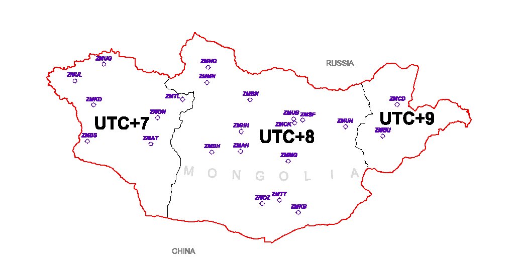
The territory of Mongolia is divided into three time zones.
Local time (LT) difference from Coordinated Universal Time (UTC) is shown the figure below:
3. Horizontal reference system
All published geographical coordinates indicating latitude and longitude are expressed in terms of the World Geodetic System-1984 (WGS-84) geodetic reference datum.
Projection is expressed in terms of Universal Transverse Mercator (UTM) and Mongolia is located in Northern Hemisphere zones 45-50 of UTM.
Ellipsoid is expressed in terms of the World Geodetic System-1984 (WGS-84) ellipsoid.
The World Geodetic System-1984 (WGS-84) is used.
The area of application for the published geographical coordinates coincides with the area of responsibility of the Aeronautical Information Service, i.e. the entire territory of Ulaanbaatar FIR in accordance with the regional air navigation agreement.
4. Vertical reference system
The vertical reference system corresponds to mean sea level (MSL).
The geoid model used is the Earth Gravitational Model 1996-(EGM-96).
5. Aircraft nationality and registration marks
The nationality mark for aircraft registered in Mongolia is the capital letters “JU”. The nationality mark is followed by a hyphen and a registration mark consisting of four numbers, eg. “JU-1026”
6. Public holidays
|
Name |
Date/Day |
|---|---|
|
New Year’s Day |
1st of January |
|
Mongolian New Year* |
2nd, 3rd, 4th of February |
|
International Women’s Day |
8th of March |
|
Lord Buddha’s Great Festival Day* |
16th of May |
|
Children’s Day |
1st of June |
|
Naadam-national festival, Anniversary of the People’s Revolution of Mongolia |
11th, 12th, 13th, 14th and 15th of July |
|
Chinggis Khaan Day* |
24th of November |
|
Independence day of Mongolia |
26th of November |
|
National Liberation and Independence Day |
29th of December |
Note: Air traffic services are not affected.
Note: Public holidays with asterisk (*) will be changed yearly.