ZMCK — ULAANBAATAR/Chinggis khaan
ZMCK AD 2.1 Aerodrome location indicator and name
ZMCK — ULAANBAATAR/Chinggis khaan
ZMCK AD 2.2 Aerodrome geographical and administrative data
| 1 | ARP coordinates and site at AD | 473849N 1064912E
105°, 1800m from THR 11 |
| 2 | Direction and distance from (city) | 194°, 31km (47km by road) from Ulaanbaatar downtown |
| 3 | Elevation/Reference temperature/Mean low temperature | 1367m / 24.4°C / -24.4°C |
| 4 | Geoid undulation at AD ELEV PSN | - |
| 5 | MAG VAR/Annual change | 5°W (2020) / 7.5'W |
| 6 | Name of AD operator, address, TEL and telefax numbers, e-mail address, AFS address and, if available, website address |
Chinggis khaan international airport Tel: 976-71287300 Tel: 976-71287311 Tel: 976-71287360 AFS: ZMCKYDYX SITA: UBNCKXH E-mail: airportops@nubia-llc.mn |
| 7 | Types of traffic permitted (IFR/VFR) |
IFR / VFR |
| 8 | Remarks | Reference code: 4E |
ZMCK AD 2.3 Operational hours
| 1 | Aerodrome operator |
H24 |
| 2 | Customs and immigration | H24 |
| 3 | Health and sanitation | H24 |
| 4 | AIS Briefing Office | H24 |
| 5 | ATS Reporting Office | H24 |
| 6 | MET Briefing Office | H24 |
| 7 | Air Traffic Service |
H24 |
| 8 | Fuelling | H24 |
| 9 | Handling | H24 |
| 10 | Security | H24 |
| 11 | De-icing | H24 |
| 12 | Remarks | NIL |
ZMCK AD 2.4 Handling services and facilities
| 1 | Cargo-handling facilities | Facilities handling weights up to 50t per day. |
| 2 | Fuel/oil types | TS-1 |
| 3 | Fuelling facilities/capacity | Jet fuel hydrant pit: 14pcs |
| 4 | De-icing facilities | De-icing vehicle - 1pc Location: 1. On TWY-F beside aircraft stand 7, 8, 9 2. On Apron behind aircraft stand 7, 8 Liquid: Clariant - Max Flight Sneg /type IV/ |
| 5 | Hangar space for visiting aircraft |
Will provide a limited service depending on type of aircraft. |
| 6 | Repair facilities for visiting aircraft | Repair facilities are available. |
| 7 | Remarks |
For more information on aircraft fuelling, please contact the following address: Tel: 976-71287901 Tel: 976-99099564 E-mail: ckjetfuel@mcaa.gov.mn Ground handling service available to provide all type of aircraft. Tel: 976-71287341 E-mail: contact-ghd@nubia-llc.mn |
ZMCK AD 2.5 Passenger facilities
| 1 | Hotels | In Ulaanbaatar and Zuunmod downtown |
| 2 | Restaurants | At the airport. |
| 3 | Transportation | Bus, taxi |
| 4 | Medical facilities | First aid and pharmacy at the airport. Hospitals in downtown. |
| 5 | Bank and post office | At the airport. |
| 6 | Tourist Office |
Travel information and related services at the airport. |
| 7 | Remarks |
NIL |
ZMCK AD 2.6 Rescue and fire-fighting services
| 1 | AD category for firefighting | CAT 9 |
| 2 | Rescue equipment | Firefighting truck: 3 Foaming agent: 4500L (AFFF 6%) Capacity of water: 34500L Discharge rate foam solution: 18000L/min Dry chemical powders: 750kg First aid vehicle: 1 |
| 3 | Capability for removal of disabled aircraft |
It is regulated by the cooperation contract with the air operator. |
| 4 | Remarks | The performance of the firefighting truck was calculated for 3 vehicles. |
ZMCK AD 2.7 Seasonal availability-clearing
| 1 | Types of clearing equipment | Snow removal vehicle: 8 truck |
| 2 | Clearance priorities | RWY, TWY, Apron |
| 3 | Remarks | NIL |
ZMCK AD 2.8 Aprons, taxiways and check locations/positions data
| 1 | Apron designation, surface and strength | Apron - concrete, PCN 86/R/B/X/T - asphalt, PCN 21/F/C/Y/T Hangar apron 1 - concrete, PCN 40/R/B/X/T |
| 2 | Taxiway designation, width, surface and strength | A, E - 29 m, concrete, PCN 86/R/B/X/T B, C, D, F - 23 m, concrete, PCN 86/R/B/X/T F1 - 32m, asphalt, PCN 43/F/C/X/T |
| 3 | Altimeter checkpoint location and elevation | Location / Elevation: At Apron / 1369m |
| 4 | VOR checkpoints | Location 1 - 473907.97N 1064759.80E 2 - 473841.74N 1065028.14E Shown on AD chart |
| 5 | INS checkpoints | NIL |
| 6 | Remarks | NIL |
ZMCK AD 2.9 Surface movement guidance and control system and markings
| 1 | Use of aircraft stand ID signs, TWY guide lines and visual docking/parking guidance system of aircraft stands | Aircraft stand ID signs: 1-4, 6, 6a, 6b, 7-9, 21-27 (Refer to Aircraft Parking Chart) TWY Guidance lines: Available Visual docking/parking guidance system at aircraft stands: NIL |
| 2 | RWY and TWY markings and LGT | RWY markings: Transverse stripe, pre-THR, THR, designation, TDZ, aiming point, centre line, edge RWY lights: THR, centre line, edge, endTWY markings: Centre line, edge, holding position TWY lights: Edge |
| 3 | Stop bars and RWY guard lights | Stop bars: NIL RWY guard lights: Available |
| 4 | Other RWY protection measures | - |
| 5 | Remarks | Other markings Apron safety line; Separation line of asphalt and concrete pavement of apron; Holding positions, guidance, parking and other markings of technical and service road on apron. |
ZMCK AD 2.10 Aerodrome obstacles
1. Area 2 obstacles
For Area 2 obstacles, please use the following link:
https://ais.mn/files/aip/eAIP/AREA2/ZMCKAREA2_0821.pdf
2. Area 3 obstacles
For Area 3 obstacles, please use the following link:
https://ais.mn/files/aip/eAIP/AREA3/ZMCKAREA3_0821.pdf
ZMCK AD 2.11 Meteorological information provided
| 1 | Associated MET Office | Aviation Meteorological Centre |
| 2 | Hours of service
|
H24 |
| 3 | Office responsible for TAF preparation Periods of validity |
Aviation Meteorological Centre 9, 30h |
| 4 | Trend forecast Interval of issuance |
TREND |
| 5 | Briefing/consultation provided | Personal consultation, telephone, closed circuit television, web: www.amc.namem.gov.mn, other device, self-briefing display |
| 6 | Flight documentation Language(s) used |
Charts, tabular forms, abbreviated plain language text Mongolian, English |
| 7 | Charts and other information available for briefing or consultation | Surface and upper air analysis charts, prognostic charts, significant weather charts, upper winds/temperatures charts, automated weather observation system real-time data |
| 8 | Supplementary equipment available for providing information | Doppler radar of weather, satellite data, products of world area forecast system |
| 9 | ATS units provided with information | TWR, APP, ACC |
| 10 | Climatological information | Climatology |
| 11 | Additional information (limitation of service, etc.) | AD, route, landing and take-off forecasts, AIRMET, SIGMET, AD WRNG
Tel: 976-71285024 Tel: 976-71287260 Tel: 976-71287279 |
ZMCK AD 2.12 Runway physical characteristics
| Designator
|
TRUE BRG |
Dimensions of RWY(m) |
Strength (PCN) and surface of RWY and SWY | THR coordinates RWY end coordinates THR geoid undulation |
THR elevation and highest elevation of TDZ of precision APP RWY | Slope of RWY-SWY |
|---|---|---|---|---|---|---|
| 1 | 2 | 3 | 4 | 5 | 6 | 7 |
11 |
104.63° |
3600 x 45 |
PCN 86/R/B/X/T concrete |
473903.63N 1064748.22E |
THR: 1367m |
RWY: 0.04% |
29 |
284.67° |
3600 x 45 |
PCN 86/R/B/X/T concrete |
473834.15N 1065035.10E |
THR: 1366m |
RWY: 0.04% |
| SWY dimensions (m) |
CWY dimensions (m) | Strip dimensions (m) | Dimensions of runway end safety areas (m) | Location and description of arresting system | OFZ | Remarks |
|---|---|---|---|---|---|---|
| 8 | 9 | 10 | 11 | 12 | 13 | 14 |
| - | - | 3720 x 300 |
240 х 90 |
- | - | NIL |
| - | - | 3720 x 300 |
180 х 90 |
- | - | NIL |
ZMCK AD 2.13 Declared distances
| RWY NR | TORA (m) | TODA (m) | ASDA (m) | LDA (m) |
Remarks |
|---|---|---|---|---|---|
| 1 | 2 | 3 | 4 | 5 | 6 |
11 |
3600 |
3600 |
3600 |
3600 |
NIL |
29 |
3600 |
3600 |
3600 |
3600 |
NIL |
ZMCK AD 2.14 Approach and runway lighting
| RWY Designator |
APCH LGT, Type, LEN, INTST |
THR LGT, colour, WBAR |
VASIS (MEHT) PAPI |
TDZ, LGT LEN |
|---|---|---|---|---|
| 1 | 2 | 3 | 4 | 5 |
11 |
SALS 420 m LIH |
green |
PAPI 3° Left (20.7 m) |
- |
29 |
PALS CAT I 900 m LIH |
green |
PAPI 3° Left (20.7 m) |
- |
| RWY Centre Line LGT LEN, spacing, colour, INTST |
RWY edge LGT LEN, spacing, colour, INTST |
RWY End LGT colour WBAR |
SWY LGT LEN colour |
Remarks |
|---|---|---|---|---|
| 6 | 7 | 8 | 9 | 10 |
3600m, 30m LIH |
3600m 60m white yellow LIH |
red |
|
Refer to AD Chart |
3600m, 30m LIH |
3600m 60m white yellow LIH |
red |
|
Refer to AD Chart |
ZMCK AD 2.15 Other lighting, secondary power supply
| 1 | ABN/IBN location, characteristics and operational hours | Control tower signalling beacon: At Tower Building, white/green |
| 2 |
Anemometer location and LGT |
Anemometer: LGTD, 340m from THR 11 |
| 3 | TWY edge lights, centre line lights and stop bars (if any) | Edge: TWY - A, B, C, D, E, F, F1 |
| 4 | Secondary power supply/switch-over time | Secondary power supply to all lighting at AD |
| 5 | Remarks | NIL |
ZMCK AD 2.16 Helicopter landing area
| 1 | Coordinates TLOF or THR of FATO Geoid undulation |
NIL |
| 2 | TLOF and/or FATO elevatiosn (m) | NIL |
| 3 | TLOF and FATO area dimensions, surface, strength, marking | NIL |
| 4 | True BRG of FATO | NIL |
| 5 | Declared distance available | NIL |
| 6 | APP and FATO lighting | NIL |
| 7 | Remarks | Use RWY |
ZMCK AD 2.17 ATS airspace
| 1 | Designation and lateral limits | ULAANBAATAR CTR 473341N 1063044E -
474645N 1063544E -
474117N 1070641E -
472814N 1070134E -
473341N 1063044E |
| 2 | Vertical limits |
GND-2100 m |
| 3 | Airspace classification | C |
| 4 |
Language(s) |
Ulaanbaatar tower Mongolian and English |
| 5 | Transition altitude |
3900m |
| 6 | Hours of applicability (or activation) | NIL |
| 7 | Remarks |
NIL |
ZMCK AD 2.18 ATS communication facilities
| Service designation |
Call sign |
Frequency |
SATVOICE numbers | Logon address | Hours of operation |
Remarks |
|---|---|---|---|---|---|---|
| 1 | 2 | 3 | 4 | 5 | 6 | 7 |
APP |
Ulaanbaatar approach |
120 MHz |
NIL |
NIL |
H24 |
NIL |
TWR |
Ulaanbaatar tower |
129 MHz |
NIL |
NIL |
H24 |
NIL |
AFIS |
Artsat |
5715 kHz |
NIL |
NIL |
HJ |
NIL |
SAR |
UBRCC |
121.5 MHz 5680 kHz |
NIL |
NIL |
H24 |
NIL |
ATIS |
Chinggis Khaan INFO | 123.7 MHz |
NIL |
NIL |
H24 |
NIL |
ZMCK AD 2.19 Radio navigation and landing aids
| Type of aid, MAG VAR, Type of supported OPS (For VOR/ILS/MLS, give declination) |
|
Frequency |
Hours of operation |
Position of transmitting antenna coordinates |
Elevation of DME transmitting antenna |
Service volume radius from the GBAS reference point | Remarks |
|---|---|---|---|---|---|---|---|
| 1 | 2 | 3 | 4 | 5 | 6 | 7 | 8 |
VOR/DME (5°W/ 2020) |
SER |
116.9 MHz 1203MHz CH 116X |
H24 |
473841.1N 1064908.7E |
1380 m | - | VOR/DME unusable: RDL 340°-070° (clockwise), beyond 25 NM below 3800m AMSL. |
ILS 29 (5°W/ 2020) LOC |
CDA |
109.9 MHz |
H24 |
473906.1N 1064734.3E |
- | - | LOC: 300m away FM RWY THR 11 BRG (MAG) 289° |
ILS 29 (5°W/ 2020) GP |
- | 333.8 MHz |
H24 |
473832.9N 1065019.5E |
- | - | GP: 327m inside FM RWY THR, 120m S of RCL GP angle 3.0° |
ILS/DME |
CDA |
997MHz 1060MHz (CH 36X) |
H24 |
473832.9N 1065019.5E |
1380 m |
- | ILS/DME: 327m inside FM RWY THR |
ZMCK AD 2.20 Local aerodrome regulations
1. Airport regulations
1.1 Location of engine start-up point
| № | Location |
Coordinates |
Elevation |
|
Latitude |
Longitude |
|||
| 1 | On TWY-F, behind the ACFT stand 9 | 473855.3N | 1064929.9E | 1369m |
| 2 | On TWY-F, behind the ACFT stand 3 | 473857.7N | 1064916.1E | 1369m |
| 3 | On TWY-F, abeam the ACFT stand 27 | 473900N | 1064902.9E | 1369m |
ZMCK AD 2.21 Noise abatement procedures
NIL
ZMCK AD 2.22 Flight procedures
1. Visual flight procedure
Note:
-
When VFR flight is to land at aerodrome or fly over the aerodrome control zone at an altitude of 2100m or below, the pilot should make contact with the air traffic controller of control zone before passing the following points:
-
If flying in from the east, UILDVER reporting point;
-
If flying in from the south, SUURIN or EEJ KHAD (coordination with Flight Information Center-ARTSAT) reporting point;
-
If flying in from the west, ALTANBULAG reporting point;
-
-
Transfer of control of VFR flight operating at the altitude of 2100m or below between Chinggis Khaan and Buyant-Ukhaa aerodrome control zone is to be coordinated at ULZIIT and BUGAT reporting points.
-
ALTANBULAG and SERGELEN reporting points are located close to the runway touchdown zone, therefore the following restrictions should be adhered to:
-
It is prohibited to use ALTANBULAG reporting point in the case where the time and direction of an aircraft landing on RWY 11 and taking-off to the west from RWY 29 coincides, unless otherwise approved by the air traffic control unit.
-
It is prohibited to use SERGELEN reporting point in the case where the time and direction of an aircraft landing on RWY 29 and taking-off from RWY 11 coincides, unless otherwise approved by the air traffic control unit.
-
2. Instrument flight procedure
-
ENR 1.1, ENR 1.3 and ENR 1.7;
-
Standard Departure Charts contained in AD 2-ZMCK-9-1, AD 2-ZMCK-9-3, AD 2-ZMCK-9-5, AD 2-ZMCK-9-7 AD 2-ZMCK-9-9, AD 2-ZMCK-9-11, AD 2-ZMCK-9-13, AD 2-ZMCK-9-15, AD 2-ZMCK-9-17 AD 2-ZMCK-9-19 and AD 2-ZMCK-9-21;
-
Standard Arrival Charts contained in AD 2-ZMCK-11-1, AD 2-ZMCK-11-3, AD 2-ZMCK-11-5, AD 2-ZMCK-11-7 and AD 2-ZMCK-11-9;
-
Instrument Approach Charts contained in AD 2-ZMCK-13-1, AD 2-ZMCK-13-3, AD 2-ZMCK-13-5, AD 2-ZMCK-13-7, AD 2-ZMCK-13-9, AD 2-ZMCK-13-11, AD 2-ZMCK-13-13, AD 2-ZMCK-13-15, AD 2-ZMCK-13-17, AD 2-ZMCK-13-19, AD 2-ZMCK-13-21 and AD 2-ZMCK-13-23.
ZMCK AD 2.23 Additional information
1. Fuel dumping area
Information concerning the fuel dumping area of Chinggis Khaan international airport is shown below.

2. Bird concentration in the vicinity of aerodrome
The airport is located near a lake and a small river on the border of the Khentii mountainous region and steppe zone, so in addition to steppe and wetland birds, forest and water birds can be found during migration. 125 species of birds have been recorded in vicinity of Chinggis Khaan International Airport, 85.7% of which are migratory. Also, 17 resident and egg-laying species, 16 migratory species, 3 non-laying summer species, and 3 winter species were recorded.There are 83 common bird species, 73% of which are migratory.
1,884 (frequency (n)=476) individual birds of 34 species were recorded in the aerodrome area, of which the horned lark was the most numerous.
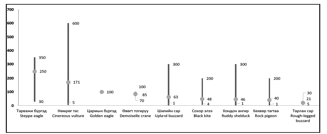
Among the birds with a high risk of endangering the aircraft are the red-billed chough, upland buzzard, cinerious vulture, black kite, demoiselle crane, ruddy shelduck, northern raven, whooper swan and the Mongolian gull. Demoiselle cranes, black kites, and ruddy shelducks lay migratory eggs, while red-billed choughs, upland buzzards, cinerious vultures, and northern ravens are residential breeders. Mongolian gulls and whooper swans does not breed near the airport and only pass through during spring and autumn migration. Birds at risk of endangering aircraft such as red-billed chough, cinereous vulture, demoiselle crane, upland buzzard, ruddy shelduck, black kite and whooper swan.
Table-1. Information on high-risk birds in the vicinity of aerodrome at Chinggis Khaan international airport
| № | Name of the bird |
Weight (gr |
Flight height (m |
Average density of birds per square km
Average density of birds per 1km square in the bird concentrations area |
Habitat |
|---|---|---|---|---|---|
| 1 | Red-billed chough |
280-430 | 1-100 | 1.2 | Steppe, settlement |
| 2 | Cinereous vulture |
7500-12000 | 1-1000 | 0.01 | Steppe, high mountain |
| 3 | Demoiselle crane |
2000-3000 | 1-150 |
0.05 |
Steppe, wetlands |
| 4 | Upland buzzard |
1000-1300 | 1-200 | 0.15 |
Steppe, grassland |
| 5 | Ruddy shelduck |
900-1600 | 1-300 | 3.98 | Wetlands |
| 6 | Black kite |
800-1100 | 1-400 | 0.05 | Steppe, |
| 7 | Whooper swan |
10000-12000 | 1-100 | 2.9 | Wetlands |
| 8 | Northern raven |
800-1500 | 1-100 | 0.05 | Steppe, settlement |
| 9 | Mongolian gull |
1000-1800 | 1-100 | 0.01 | Wetlands, river valley, meadows |
Table-2. Length of stay of high-risk birds in the vicinity of aerodrome at Chinggis Khaan international airport.

Graphic 1. Bird activity near the aerodrome of Chinggis Khaan international airport
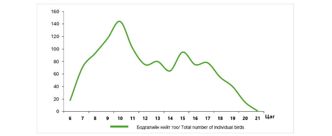
The location with bird concentration near the terminal areas are illustrated in chart AD 2-ZMCK-15-1 "Bird concentrations in the vicinity of aerodrome" The location with bird concentration near the terminal control area is illustrated in chart AD2-ZMCK-24 “Bird concentrations in the vicinity of aerodrome”
Graphic-1. Average flight height of high-risk birds in the vicinity of aerodrome at Chinggis Khaan international airport (meter)
Following birds flew relatively high such as cinereous vulture, steppe eagle, golden eagle, demoiselle crane, upland buzzard, black kite, ruddy shelduck and rock pigeon.
ZMCK AD 2.24 Charts related to aerodromes
|
|
Хуудас/Page |
|---|---|
Aerodrome Chart-ICAO |
AD 2-ZMCK-2-1 |
Aerodrome Chart-ICAO |
AD 2-ZMCK-2-2 |
Aircraft Parking Chart-ICAO |
AD 2-ZMCK-3-1 |
Aircraft Parking Chart-ICAO |
AD 2-ZMCK-3-2 |
Standard Departure Chart-Instrument (SID)-ICAO (RWY 11/29 TOROV 2A/2B) |
AD 2-ZMCK-9-1 |
Conversion table (SID)-ICAO (RWY 11/29 TOROV 2A/2B) |
AD 2-ZMCK-9-2 |
Standard Departure Chart-Instrument (SID)-ICAO (RWY 11/29 LUBSO 2A/2B) |
AD 2-ZMCK-9-3 |
Conversion table (SID)-ICAO (RWY 11/29 LUBSO 2A/2B) |
AD 2-ZMCK-9-4 |
Standard Departure Chart-Instrument (SID)-ICAO (RWY 11/29 ISMIN 2A/2B) |
AD 2-ZMCK-9-5 |
Conversion table (SID)-ICAO (RWY 11/29 ISMIN 2A/2B) |
AD 2-ZMCK-9-6 |
Standard Departure Chart-Instrument (SID)-ICAO (RWY 11/29 MENUG 2A/2B) |
AD 2-ZMCK-9-7 |
Conversion table (SID)-ICAO (RWY 11/29 MENUG 2A/2B) |
AD 2-ZMCK-9-8 |
Standard Departure Chart-Instrument (SID)-ICAO (RWY 11/29 TATIG 2A/2B) |
AD 2-ZMCK-9-9 |
AeronauticalData Tabulation (SID)-ICAO (RWY 11/29 TATIG 2A/2B) |
AD 2-ZMCK-9-10 |
Standard Departure Chart-Instrument (SID)-ICAO (RNAV(GNSS) RWY 11/29 TOROV 2C/2D) |
AD 2-ZMCK-9-11 |
Aeronautical Data Tabulation (SID)-ICAO (RNAV(GNSS) RWY 11/29 TOROV 2C/2D) |
AD 2-ZMCK-9-12 |
Standard Departure Chart-Instrument (SID)-ICAO (RNAV(GNSS) RWY 11/29 LUBSO 2C/3D) |
AD 2-ZMCK-9-13 |
Aeronautical Data Tabulation (SID)-ICAO (RNAV(GNSS) RWY 11/29 LUBSO 2C/3D) |
AD 2-ZMCK-9-14 |
Standard Departure Chart-Instrument (SID)-ICAO (RNAV(GNSS) RWY 11/29 ISMIN 2C/2D) |
AD 2-ZMCK-9-15 |
Aeronautical Data Tabulation (SID)-ICAO (RNAV(GNSS) RWY 11/29 ISMIN 2C/2D) |
AD 2-ZMCK-9-16 |
Standard Departure Chart-Instrument (SID)-ICAO (RNAV(GNSS) RWY 11/29 MENUG 2C/2D) |
AD 2-ZMCK-9-17 |
Aeronautical Data Tabulation (SID)-ICAO (RNAV(GNSS) RWY 11/29 MENUG 2C/2D) |
AD 2-ZMCK-9-18 |
Standard Departure Chart-Instrument (SID)-ICAO (RNAV(GNSS) RWY 11 BURKU 2D) |
AD 2-ZMCK-9-19 |
Aeronautical Data Tabulation (SID)-ICAO (RNAV(GNSS) RWY 11 BURKU 2D) |
AD 2-ZMCK-9-20 |
Standard Departure Chart-Instrument (SID)-ICAO (RNAV(GNSS) RWY 11/29 EGERO 2C/2D) |
AD 2-ZMCK-9-21 |
Aeronautical Data Tabulation (SID)-ICAO (RNAV(GNSS) RWY 11/29 EGERO 2C/2D) |
AD 2-ZMCK-9-22 |
Standard Arrival Chart-Instrument (STAR)-ICAO (RWY 11 LUBSO 2X, TOROV 2X, MENUG 2X, TATIG 2X) |
AD 2-ZMCK-11-1 |
Conversion table (STAR)-ICAO (RWY 11 LUBSO 2X, TOROV 2X, MENUG 2X, TATIG 2X) |
AD 2-ZMCK-11-2 |
Standard Arrival Chart-Instrument (STAR)-ICAO (RWY 29 LUBSO 2Z, TOROV 2Z, MENUG 2Y) |
AD 2-ZMCK-11-3 |
Conversion table (STAR)-ICAO (RWY 29 LUBSO 2Z, TOROV 2Z, MENUG 2Y) |
AD 2-ZMCK-11-4 |
Standard Arrival Chart-Instrument (STAR)-ICAO (RWY 29 MENUG 2Z, TATIG 2Z) |
AD 2-ZMCK-11-5 |
Conversion table (STAR)-ICAO (RWY 29 MENUG 2Z, TATIG 2Z) |
AD 2-ZMCK-11-6 |
Standard Arrival Chart-Instrument (STAR)-ICAO (RNAV(GNSS) RWY 11 LUBSO 2V, TOROV 2V, MENUG 2V, TATIG 2V) |
AD 2-ZMCK-11-7 |
Conversion table (STAR)-ICAO (RNAV(GNSS) RWY 11 LUBSO 2V, TOROV 2V, MENUG 2V, TATIG 2V) |
AD 2-ZMCK-11-8 |
Standard Arrival Chart-Instrument (STAR)-ICAO (RNAV(GNSS) RWY 29 TOROV 2W, MENUG 2W, EGERO 2W, TATIG 2W) |
AD 2-ZMCK-11-9 |
Conversion table (STAR)-ICAO (RNAV(GNSS) RWY 29 TOROV 2W, MENUG 2W, EGERO 2W, TATIG 2W) |
AD 2-ZMCK-11-10 |
Instrument Approach Chart-ICAO (VOR Z RWY 11 ACFT CAT A/B, C/D) |
AD 2-ZMCK-13-1 |
Conversion table (VOR Z RWY 11 ACFT CAT A/B, C/D) |
AD 2-ZMCK-13-2 |
Instrument Approach Chart-ICAO (VOR Z RWY 29 ACFT CAT A/B, C/D) |
AD 2-ZMCK-13-3 |
Conversion table (VOR Z RWY 29 ACFT CAT A/B, C/D) |
AD 2-ZMCK-13-4 |
Instrument Approach Chart-ICAO (VOR Y RWY 11 ACFT CAT A/B, C/D) |
AD 2-ZMCK-13-5 |
Conversion table (VOR Y RWY 11 ACFT CAT A/B, C/D) |
AD 2-ZMCK-13-6 |
Instrument Approach Chart-ICAO (VOR Y RWY 29 ACFT CAT A/B, C/D) |
AD 2-ZMCK-13-7 |
Conversion table (VOR Y RWY 29 ACFT CAT A/B, C/D) |
AD 2-ZMCK-13-8 |
Instrument Approach Chart-ICAO (ILS Z RWY 29 ACFT CAT A/B, C/D) |
AD 2-ZMCK-13-9 |
Conversion table (ILS Z RWY 29 ACFT CAT A/B, C/D) |
AD 2-ZMCK-13-10 |
Instrument Approach Chart-ICAO (ILS Y RWY 29 ACFT CAT A/B, C/D) |
AD 2-ZMCK-13-11 |
Conversion table (ILS Y RWY 29 ACFT CAT A/B, C/D) |
AD 2-ZMCK-13-12 |
Instrument Approach Chart-ICAO (ILS X RWY 29 ACFT CAT A/B, C/D) |
AD 2-ZMCK-13-13 |
Aeronautical Data Tabulation (ILS X RWY 29 ACFT CAT A/B, C/D) |
AD 2-ZMCK-13-14 |
Instrument Approach Chart-ICAO (LOC Z RWY 29 ACFT CAT A/B, C/D) |
AD 2-ZMCK-13-15 |
Conversion table (LOC Z RWY 29 ACFT CAT A/B, C/D) |
AD 2-ZMCK-13-16 |
Instrument Approach Chart-ICAO (LOC Y RWY 29 ACFT CAT A/B, C/D) |
AD 2-ZMCK-13-17 |
Conversion table (LOC Y RWY 29 ACFT CAT A/B, C/D) |
AD 2-ZMCK-13-18 |
Instrument Approach Chart-ICAO (LOC X RWY 29 ACFT CAT A/B, C/D) |
AD 2-ZMCK-13-19 |
Aeronautical Data Tabulation (LOC X RWY 29 ACFT CAT A/B, C/D) |
AD 2-ZMCK-13-20 |
Instrument Approach Chart-ICAO (RNP RWY 11 (LNAV only) ACFT CAT A/B, C/D) |
AD 2-ZMCK-13-21 |
Aeronautical Data Tabulation (RNP RWY 11 (LNAV only) ACFT CAT A/B, C/D) |
AD 2-ZMCK-13-22 |
Instrument Approach Chart-ICAO (RNP RWY 29 (LNAV only) ACFT CAT A/B, C/D) |
AD 2-ZMCK-13-23 |
Aeronautical Data Tabulation (RNP RWY 29 (LNAV only) ACFT CAT A/B, C/D) |
AD 2-ZMCK-13-24 |
Visual Reporting Points Chart (Visual REP) |
AD 2-ZMCK-14-1 |
Bird concentrations in the vicinity of aerodrome |
AD 2-ZMCK-15-1 |