ENR 1.7 Altimeter setting procedures
1. Introduction
The altimeter setting procedures in use generally conform to those contained in ICAO Doc 8168.
Transition altitudes are given on the instrument approach charts and under AD 2.17.
QNH reports and temperature information for use are provided by automatic terminal information service (ATIS) and are available on request from the air traffic services units. QNH values are given in hectopascals.
2. Basic altimeter setting procedures
when operating at or above the established transition altitude for that aerodrome, set altimeter to 1013.25hPa (760mmHg);
when operating at or below the established transition level for that aerodrome, set altimeter to the aerodrome QNH and QFE altimeter setting;
when operating between the transition altitude and the transition level, maintain the altitude or the flight level as authorised by ATC.
3. Description of altimeter setting region
Not applicable.
4. Procedures applicable to operators (including pilots)
The levels at which a flight is to be conducted shall be specified in the flight plan:
in terms of flight levels if the flight is to be conducted at or above the transition level;
in terms of altitudes if the flight is to be conducted in the vicinity of an aerodrome and at or below the transition altitude.
5. Table of cruising levels
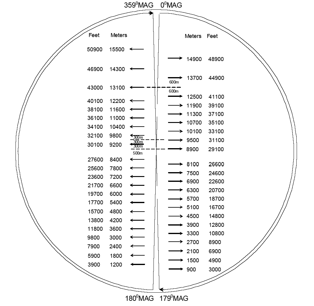
Note: ATC will issue the flight level clearance in meters. Pilot shall use the Mongolia RVSM FLAS Diagram to determine the corresponding flight level in feet. The aircraft shall be flown using the flight level in FEET. Pilots should be aware that due to the rounding differences, the metric readout of the onboard avionics will not necessarily correspond to the cleared flight level in meters however the difference will never be more than 30 meters.
| 180°-359°MAG | 000°-179°MAG | ||
|---|---|---|---|
|
Flight levels |
Flight levels | ||
| M | FT | M | FT |
| 15500 | 50900 | 14900 | 48900 |
| 14300 | 46900 | 13700 | 44900 |
| 13100 | 43000 | ||
| 12500 | 41100 | ||
| 12200 | 40100 | 11900 | 39100 |
| 11600 | 38100 | 11300 | 37100 |
| 11000 | 36100 | 10700 | 35100 |
| 10400 | 34100 | 10100 | 33100 |
| 9800 | 32100 | 9500 | 31100 |
| 9200 | 30100 | 8900 | 29100 |
| 8400 | 27600 | 8100 | 26600 |
| 7800 | 25600 | 7500 | 24600 |
| 7200 | 23600 | 6900 | 22600 |
| 6600 | 21700 | 6300 | 20700 |
| 6000 | 19700 | 5700 | 18700 |
| 5400 | 17700 | 5100 | 16700 |
| 4800 | 15700 | 4500 | 14800 |
| 4200 | 13800 | 3900 | 12800 |
| 3600 | 11800 | 3300 | 10800 |
| 3000 | 9800 | 2700 | 8900 |
| 2400 | 7900 | 2100 | 6900 |
| 1800 | 5900 | 1500 | 4900 |
| 1200 | 3900 | 900 | 3000 |
Note: The following vertical separation is required between all flights conducted in the airspace of Mongolia:
-
300m up to the flight level of 8400m;
-
500m between the flight levels 8400m and 8900m;
-
300m between the flight levels 8900m and 12500m;
-
600m above the flight level 12500m.