GEN 3.2 Aeronautical charts
1. Responsible service
2. Maintenance of charts
3. Purchase arrangements
Aeronautical Information Services Division
Buyant-Ukhaa International Airport
P.O.Box-59
Ulaanbaatar 17120
Mongolia
Tel: 976-71283121
Fax: 976-70049838
E-mail: chart@ncac.mn
URL: www.ais.mn
Note: The operational hours are MON-FRI: 00:00-09:00 UTC.
4. Aeronautical chart series available
Aerodrome chart - ICAO;
Aircraft Parking/Docking Chart - ICAO;
En-route Chart - ICAO;
Standard Departure Chart - Instrument (SID) - ICAO;
Standard Arrival Chart – instrument (STAR) – ICAO;
Instrument Approach Chart – ICAO (for each runway and procedure type);
Visual Approach Chart - ICAO;
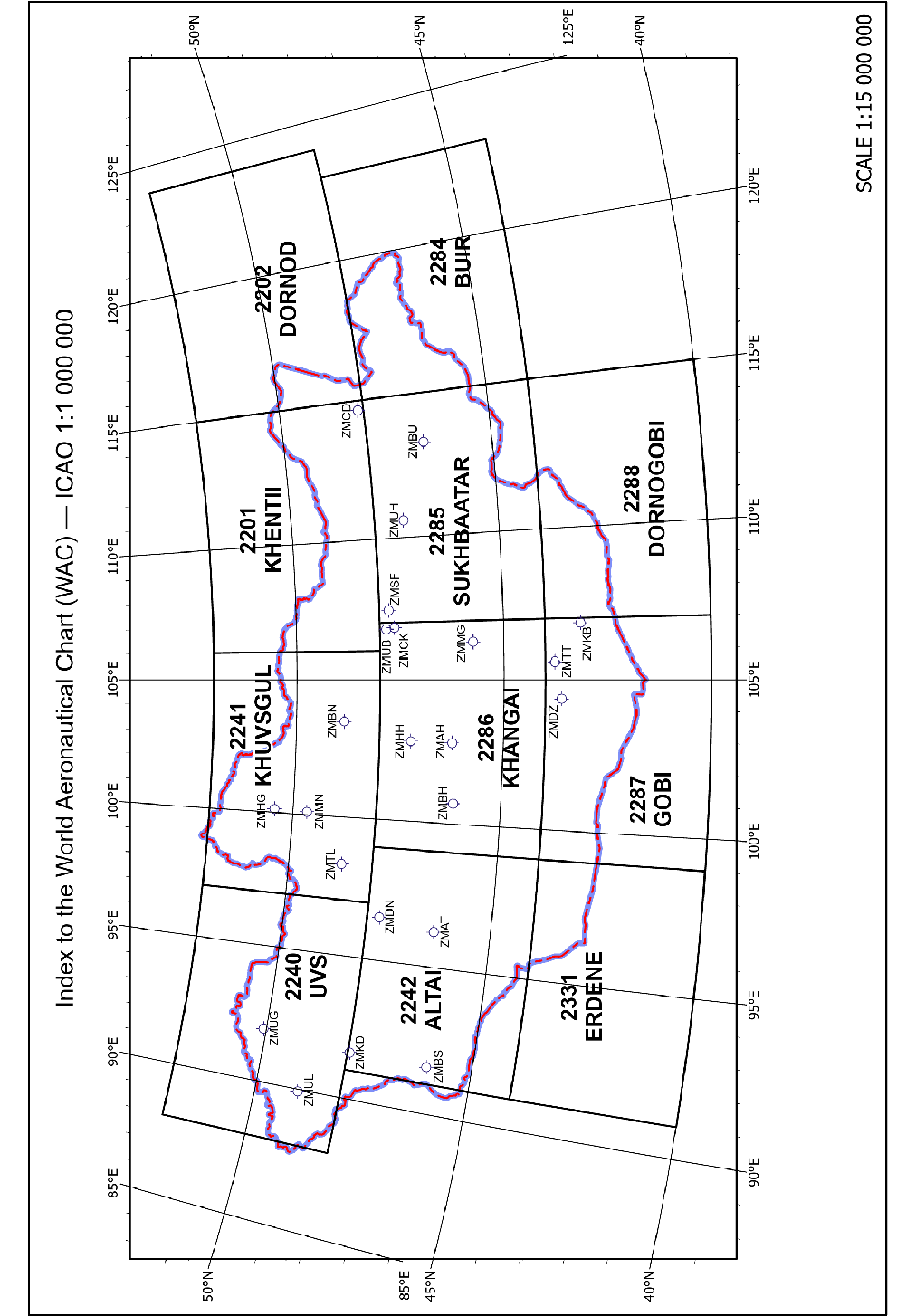
World Aeronautical Chart (WAC) - ICAO 1:1000000;
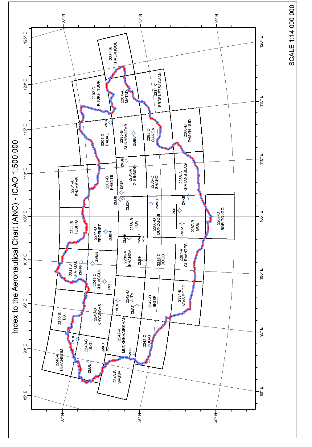
Aeronautical Chart – ICAO 1:500000.
Heliport chart;
Visual reporting points chart;
Bird concentrations in the vicinity of aerodrome;
Munkh-Ulziit radar coverage in Ulaanbaatar TMA;
Prohibited and Restricted areas in the vicinity of Buyant – Ukhaa aerodrome – index chart.
Note: “Aerodrome Obstacle Chart - ICAO Type A” is not published for Chinggis Khaan International Airport and Buyant-Ukhaa International Airport, Choibalsan International Airport, Khovd International Airport and Muren International Airport because no obstacles exist in the take-off flight path area.
The charts currently available are listed under GEN 3.2.5.
Aerodrome Chart - ICAO
This chart shall provide flight crews with information which will facilitate the ground movement of aircraft:
from the aircraft stand to the runway; and
from the runway to the aircraft stand.
Heliport Chart
This chart contains detailed heliport data to provide flight crew with information that will facilitate the ground movement of helicopter:
along helicopter ground and air taxiways
Aircraft Parking/Docking Chart - ICAO
This supplementary chart shall provide flight crews with detailed information to facilitate the ground movement of aircraft between the taxiways and the aircraft stands and the parking/docking of aircraft.
En-route Chart - ICAO
This chart shall provide flight crews with information to facilitate navigation along ATS routes in compliance with air traffic services procedures.
Standard Departure Chart - Instrument (SID) - ICAO
This chart shall provide the flight crew with information to enable it to comply with the designated standard departure route — instrument from take-off phase to the en-route phase.
Standard Arrival Chart — Instrument (STAR) - ICAO
This chart shall provide the flight crew with information to enable it to comply with the designated standard arrival route— instrument from the en-route phase to the approach phase.
Instrument Approach Chart - ICAO
This chart shall provide flight crews with information which will enable them to perform an approved instrument approach procedure to the runway of intended landing including the missed approach procedure and, where applicable, associated holding patterns.
Visual Approach Chart - ICAO
This chart shall provide flight crews with information which will enable them to transit from the en-route/descent to approach phases of flight to the runway of intended landing by means of visual reference.
World Aeronautical Chart (WAC) - ICAO 1:1000000
This chart shall provide information to satisfy the requirements of visual air navigation.
Aeronautical Chart – ICAO 1:500000
This chart shall provide information to satisfy the requirements of visual air navigation for low speed, short- or medium-range operations at low and intermediate altitudes.
5. List of aeronautical charts available
| № |
Title of series |
Scale |
Name and/or number | Unit price |
Date of latest revision |
|---|---|---|---|---|---|
| 1 |
En-route chart - ICAO | 1:3000000 |
ENRC | MNT 56400 |
17 APR 2025 |
| 2 |
World Aeronautical Chart - ICAO | 1:1000000 |
- 2240 UVS |
MNT 28200 | 11 JAN 2024 |
|
- 2241 KHUVSGUL | |||||
|
- 2201 KHENTII | |||||
|
- 2202 DORNOD | |||||
|
- 2242 ALTAI | |||||
|
- 2286 KHANGAI | |||||
|
- 2285 SUKHBAATAR | |||||
|
- 2284 BUIR | |||||
|
- 2331 ERDENE | |||||
|
- 2287 GOBI | |||||
|
- 2288 DORNOGOBI | |||||
| 3 |
Aeronautical Chart – ICAO | 1:500000 |
2201-A SHAAMAR |
MNT 28200 | 06 OCT 2022 |
|
2201-C KHENTII | 11 JAN 2024 | ||||
|
2201-D DADAL | 06 OCT 2022 | ||||
|
2202-C KHUKH NUUR | 06 OCT 2022 | ||||
|
2240-A ULAANGOM | 06 OCT 2022 | ||||
|
2240-B TES | 06 OCT 2022 | ||||
|
2240-C ULGII | 06 OCT 2022 | ||||
|
2240-D KHYARGAS | 06 OCT 2022 | ||||
|
2241-A KHATGAL | 06 OCT 2022 | ||||
|
2241-B TUSHIG | 06 OCT 2022 | ||||
|
2241-C KHUVSGUL | 06 OCT 2022 | ||||
|
2241-D ERDENET | 06 OCT 2022 | ||||
| 2242-A MUNKHKHAIRKHAN | 06 OCT 2022 | ||||
|
2242-B ALTAI | 06 OCT 2022 | ||||
|
2242-C BUGAT | 06 OCT 2022 | ||||
|
2242-D BIGER | 06 OCT 2022 | ||||
|
2243-B SAGSAI | 06 OCT 2022 | ||||
|
2284-A MATAD | 06 OCT 2022 | ||||
|
2284-B KHALKHGOL | 06 OCT 2022 | ||||
|
2284-C ERDENETSAGAAN | 06 OCT 2022 | ||||
|
2285-A ZUUN MOD | 11 JAN 2024 | ||||
|
2285-B SUKHBAATAR | 06 OCT 2022 | ||||
|
2285-C SHAND | 06 OCT 2022 | ||||
|
2285-D GANGA | 06 OCT 2022 | ||||
|
2286-A KHANGAI | 06 OCT 2022 | ||||
|
2286-B TUV | 11 JAN 2024 | ||||
|
2286-C BOGD | 06 OCT 2022 | ||||
|
2286-D DUNDGOBI | 10 AUG 2023 | ||||
|
2287-A GURVANTES | 06 OCT 2022 | ||||
|
2287-B GOBI | 10 AUG 2023 | ||||
|
2287-D BOR TOLGOI | 06 OCT 2022 | ||||
|
2288-A KHATANBULAG | 06 OCT 2022 | ||||
|
2288-B ZAMYN-UUD | 06 OCT 2022 | ||||
|
2331-B ATAS BOGD | 06 OCT 2022 |
Note: Value Added Tax (VAT) is applicable.
|
№ |
Aerodrome name/locationindicator |
Title of series and name of chart |
Scale |
Date of latest revision |
|---|---|---|---|---|
|
1 |
Arvaikheer/ZMAH |
Aerodrome Chart - ICAO |
1:16000 |
REF to AIP page |
|
2 |
Altai/ZMAT |
Aerodrome Chart - ICAO |
1:15000 | |
|
Standard Departure Chart - Instrument (SID) -ICAO - RWY 10 BH 1A, IGOMA 2A, ODOKU 2A ACFT CAT B/C |
1:780000 | |||
|
Instrument Approach Chart - ICAO - VOR Z RWY 28 ACFT CAT B - VOR Y RWY 28 ACFT CAT B/C - RNP RWY 28 (LNAV only) ACFT CAT B/C |
1:390000 1:390000 1:390000 | |||
|
Bird concentrations in the vicinity of aerodrome |
1:200000 | |||
|
3 |
Bayankhongor/ZMBH |
Aerodrome Chart - ICAO |
1:16000 | |
|
4 |
Bulgan/ZMBN |
Aerodrome Chart - ICAO |
1:12000 | |
|
5 |
Bulgan sum/ZMBS |
Aerodrome Chart - ICAO |
1:10000 | |
|
6 |
Baruun-Urt/ZMBU |
Aerodrome Chart - ICAO |
1:13000 | |
|
7 |
Choibalsan/ZMCD |
Aerodrome Chart - ICAO |
1:18000 | |
|
Standard Departure Chart - Instrument (SID) -ICAO - OMNIDIRECTIONAL DEPARTURE RWY 12/30 ACFT CAT A/B/C |
1:220000 | |||
|
Instrument Approach Chart – ICAO - NDB Z RWY 12 ACFT CAT A/B - NDB Y RWY 12 ACFT CAT C - NDB Z RWY 30 ACFT CAT A/B - NDB Y RWY 30 ACFT CAT C - NDB X RWY 30 ACFT CAT A/B, C - RNP RWY 12 (LNAV only) ACFT CAT A/B, C - RNP RWY 30 (LNAV only) ACFT CAT A/B, C |
1:220000 1:220000 1:250000 1:250000 1:250000 1:300000 1:300000 | |||
|
8 |
Chinggis khaan/ZMCK |
Aerodrome Chart - ICAO |
1:14000 | |
|
Aircraft Parking/Docking Chart - ICAO |
1:3200 | |||
|
Standard Departure Chart - Instrument (SID) -ICAO - RWY 11/29 TOROV 2A/2B - RWY 11/29 LUBSO 2A/2B - RWY 11/29 ISMIN 2A/2B - RWY 11/29 MENUG 2A/2B - RWY 11/29 TATIG 2A/2B - RNAV(GNSS) RWY 11/29 TOROV 2C/2D - RNAV(GNSS) RWY 11/29 LUBSO 2C/3D - RNAV(GNSS) RWY 11/29 ISMIN 2C/2D - RNAV(GNSS) RWY 11/29 MENUG 2C/2D - RNAV(GNSS) RWY 11 BURKU 2D - RNAV(GNSS) RWY 11/29 EGERO 2C/2D |
1:530000 1:520000 1:520000 1:550000 1:520000 1:590000 1:520000 1:650000 1:650000 1:520000 1:650000 | |||
|
Standard Arrival Chart — Instrument (STAR) - ICAO - RWY 11 LUBSO 2X, TOROV 2X, MENUG 2X, TATIG 2X - RWY 29 LUBSO 2Z, TOROV 2Z, MENUG 2Y - RWY 29 MENUG 2Z, TATIG 2Z - RNAV(GNSS) RWY 11 LUBSO 2V, TOROV 2V, MENUG 2V,TATIG 2V - RNAV(GNSS) RWY 29 TOROV 2W, MENUG 2W, EGERO 2W, TATIG 2W |
1:650000 1:650000 1:650000 1:650000
1:650000 |
REF to AIP page | ||
|
Instrument Approach Chart – ICAO - VOR Z RWY 11 ACFT CAT A/B, C/D - VOR Z RWY 29 ACFT CAT A/B, C/D - VOR Y RWY 11 ACFT CAT A/B, C/D - VOR Y RWY 29 ACFT CAT A/B, C/D - ILS Z RWY 29 ACFT CAT A/B, C/D - ILS Y RWY 29 ACFT CAT A/B, C/D - ILS X RWY 29 ACFT CAT A/B, C/D - LOC Z RWY 29 ACFT CAT A/B, C/D - LOC Y RWY 29 ACFT CAT A/B, C/D - LOC X RWY 29 ACFT CAT A/B, C/D - RNP RWY 11 (LNAV only) ACFT CAT A/B, C/D - RNP RWY 29 (LNAV only) ACFT CAT A/B, C/D |
1:530000 1:440000 1:370000 1:370000 1:370000 1:370000 1:370000 1:370000 1:370000 1:370000 1:420000 1:370000 | |||
| Visual reporting points chart | 1:700000 | |||
| Bird concentrations in the vicinity of aerodrome | 1:125000 | |||
|
9 |
Otgontenger/ZMDN |
Aerodrome Chart - ICAO |
1:17500 | |
|
10 |
Gurvansaikhan/ZMDZ |
Aerodrome Chart - ICAO |
1:15000 | |
|
Instrument Approach Chart – ICAO - NDB RWY 29 ACFT CAT A/B, C |
1:350000 | |||
|
11 |
Khatgal/ZMHG |
Aerodrome Chart - ICAO |
1:13000 | |
|
12 |
Kharkhorin/ZMHH |
Aerodrome Chart - ICAO |
1:10000 | |
|
13 |
Khanbumbat/ZMKB |
Aerodrome Chart - ICAO |
1:12000 | |
|
Instrument Approach Chart – ICAO - NDB RWY 16 ACFT CAT A/B,C/D - NDB RWY 34 ACFT CAT A/B,C/D |
1:340000 1:340000 | |||
|
14 |
Khovd/ZMKD |
Aerodrome Chart - ICAO |
1:16000 | |
|
Standard Departure Chart - Instrument (SID) -ICAO - RWY 16/34 PANTI 2A/2B ACFT CAT A/B/C - RWY 16/34 RUNIS 2A/2B ACFT CAT A/B/C - RWY 16/34 OBGUM 2A/2B ACFT CAT A/B/C |
1:500000 1:500000 1:500000 | |||
|
Instrument Approach Chart – ICAO - RNP RWY 34 (LNAV only) ACFT CAT A/B/C |
1:370000 | |||
|
15 |
Mandalgobi/ZMMG |
Aerodrome Chart - ICAO |
1:10000 | |
|
16 |
Muren/ZMMN |
Aerodrome Chart - ICAO |
1:14000 |
REF to AIP page |
|
Standard Departure Chart - Instrument (SID) -ICAO - RWY 10/28 MUBUR 2A/2B ACFT CAT A/B/C - RWY 10/28 PAGDI 2A/2B ACFT CAT A/B/C - RWY 28 ASUBU 2B ACFT CAT A/B/C |
1:450000 1:450000 1:450000 | |||
|
Instrument Approach Chart – ICAO - NDB Z RWY 28 ACFT CAT A/B - NDB Y RWY 28 ACFT CAT C - RNP RWY 28 (LNAV only) ACFT CAT A/B/C |
1:420000 1:420000 1:350000 | |||
|
17 |
Sky friends/ZMSF |
Aerodrome Chart - ICAO |
1:5000 | |
|
18 |
Tosontsengel/ZMTL |
Aerodrome Chart - ICAO |
1:14000 | |
|
Bird concentrations in the vicinity of aerodrome |
1:58000 | |||
|
19 |
Tavan tolgoi/ZMTT |
Aerodrome Chart - ICAO |
1:13000 | |
|
20 |
Buyant-Ukhaa/ZMUB |
Aerodrome Chart - ICAO |
1:12000 | |
|
Aircraft Parking/Docking Chart - ICAO |
1:5000 | |||
|
Standard Departure Chart - Instrument (SID) -ICAO - VOR/DME RWY 32 TATIG 3E, TOROV 3E/3F, SER 2F,DUKIM 3E, LUBSO 3E - NDB RWY 32 TATIG 3G, TOROV 4G/3H, SER 1B, DUKIM 3G, LUBSO 4G |
1:520000
1:520000
| |||
|
Instrument Approach Chart – ICAO - VOR/DME RWY 14 ACFT CAT A/B, C/D - NDB RWY 14 ACFT CAT A/B, C/D - NDB/DME RWY 14 ACFT CAT A/B, C/D - ILS RWY 14 ACFT CAT A/B, C/D - RNP RWY 14 (LNAV only) ACFT CAT A/B/C/D |
1:280000 1:330000 1:280000 1:340000 1:370000 | |||
| Visual reporting points chart | 1:700000 | |||
|
Bird concentrations in the vicinity of aerodrome |
1:200000 | |||
|
21 |
Deglii tsagaan/ZMUG |
Aerodrome Chart - ICAO |
1:15000 | |
|
Standard Departure Chart - Instrument (SID) -ICAO - RWY 31/13 SADGO 2A/2B ACFT CAT A/B/C - RWY 13 URBUM 2B ACFT CAT A/B/C - RWY 31 MIBUT 2A ACFT CAT A/B/C |
1:600000 1:600000 1:600000 | |||
|
Standard Arrival Chart — Instrument (STAR) - ICAO - RNAV (GNSS) RWY 31 SADGO2 MIBUT2 |
1:570000 | |||
|
Instrument Approach Chart – ICAO - NDB RWY 31 ACFT CAT A/B, C - RNP RWY 31 (LNAV only) ACFT CAT A/B, C |
1:280000 1:560000 | |||
|
22 |
Undurkhaan/ZMUH |
Aerodrome Chart - ICAO |
1:14000 | |
|
23 |
Ulgii/ZMUL |
Aerodrome Chart - ICAO | 1:12000 | |
|
Visual Approach Chart - RNP RWY 31 (VISUAL) ACFT CAT B/C |
1:370000 |
|
№ |
Heliport name/location indicator |
Title of series and name of chart |
Scale |
Date of latest revision |
|---|---|---|---|---|
| 1 | Bogd khan/ZMBK | Heliport chart | 1:200 |
REF to AIP page |
6. Index to the World Aeronautical Chart (WAC) - ICAO 1:1000000
6.1 Index to the Aeronautical Chart (ANC) - ICAO 1:500000
7. Topographical charts
A wide range of topographical charts is available from:
State administrative regulatory body of geodesy and cartography
Governmental building-XII, Barilgachdiin talbai, Chingeltei district,
Ulaanbaatar 15170,
Mongolia
Tel: 976-18000101
Fax: 976-51-260203
E-mail: info@gazar.gov.mn
URL: www.gazar.gov.mn
8. Corrections to charts not contained in the AIP
NIL