ZMUB — ULAANBAATAR/Buyant-Ukhaa
ZMUB AD 2.1 Aerodrome location indicator and name
ZMUB — ULAANBAATAR/Buyant-Ukhaa
ZMUB AD 2.2 Aerodrome geographical and administrative data
| 1 | ARP coordinates and site at AD | 475033N 1064603E
138°, 1555m from THR 14 |
| 2 | Direction and distance from (city) | 213°, 14.7km from downtown |
| 3 | Elevation/Reference temperature/Mean low temperature | 1331 m / 25.4°C / -32.1°C |
| 4 | Geoid undulation at AD ELEV PSN | NIL |
| 5 | MAG VAR/Annual change | 5°W (2020) / 7.5'W |
| 6 | Name of AD operator, address, TEL and telefax numbers, e-mail address, AFS address and, if available, website address |
National Civil Aviation Center SOLLC Tel: 976-71283047 Tel: 976-71283001 AFS: ZMUBYDYX E-mail: airport_operation@mcaa.gov.mn URL: www.airport.gov.mn |
| 7 | Types of traffic permitted (IFR/VFR) |
IFR / VFR |
| 8 | Remarks | Reference code: 4D |
ZMUB AD 2.3 Operational hours
| 1 | Aerodrome operator | 23:30-11:30 UTC |
| 2 | Customs and immigration | HO |
| 3 | Health and sanitation | HO |
| 4 | AIS Briefing Office | HO More detailed information can be found in GEN 3.1 |
| 5 | ATS Reporting Office | H24 More detailed information can be found in ENR 1.10 |
| 6 | MET Briefing Office | H24 |
| 7 | Air Traffic Service |
H24 |
| 8 | Fuelling | HO |
| 9 | Handling | HO |
| 10 | Security | HO |
| 11 | De-icing | NIL |
| 12 | Remarks | Submit flight request to airport_operation@mcaa.gov.mn at least 3 hours in advance. |
ZMUB AD 2.4 Handling services and facilities
| 1 | Cargo-handling facilities | Baggage tractor - 2 Belt loader - 1 Container pallet loader - 1 Cargo trailer - 7 |
| 2 | Fuel/oil types | Fuel: TURBO-2389, MOBILE JET 1QT, TS-1 Oil: NIL |
| 3 | Fuelling facilities/capacity | Truck - 1/1200L/min |
| 4 | De-icing facilities | NIL |
| 5 | Hangar space for visiting aircraft |
Will provide a limited service depending on type of aircraft. |
| 6 | Repair facilities for visiting aircraft | Minor repair facilities available. |
| 7 | Remarks |
See the handling service providers information in the following AIC.“Handling service AIC A series”. |
ZMUB AD 2.5 Passenger facilities
| 1 | Hotels | In downtown. |
| 2 | Restaurants | At airport and in downtown. |
| 3 | Transportation | Taxi is available on call. |
| 4 | Medical facilities | First aid: The airport has a first aid doctor and a pharmacy. Hospital: The united hospital in the downtown |
| 5 | Bank and Post Office | Bank: At airport MON-FRI, 00:30 - 08:30 UTC Post Office: NIL |
| 6 | Tourist Office |
NIL |
| 7 | Remarks |
NIL |
ZMUB AD 2.6 Rescue and firefighting services
| 1 | AD category for firefighting | CAT 5 (CAT 8 is available on request.) |
| 2 | Rescue equipment | Firefighting truck: 3 Capacity of water: 5678L, 5678L, 7500L Capacity of foam: 795L, 795L, 500L Dry chemical substance: 250kg, 250kg |
| 3 | Capability for removal of disabled aircraft |
Aircraft towing tractor service is available. (Type of aircraft up to B737-800) Contact number: 976-71283047 Can be used as a aircraft towing tractor. (Type of aircraft up to Boeing 737-800) |
| 4 | Remarks | Same as the operating hour of the aerodrome operator. |
ZMUB AD 2.7 Seasonal availability-clearing
| 1 | Types of clearing equipment | Snow removal vehicle - 7 |
| 2 | Clearance priorities | RWY, TWY, Apron |
| 3 | Remarks | NIL |
ZMUB AD 2.8 Aprons, taxiways and check locations/positions data
| 1 | Apron designation, surface and strength | Apron, concrete, PCR 430/R/C/X/T Apron, asphalt, PCR 1400/FC/X/T |
| 2 | Taxiway designation, width, surface and strength | TWY A, TWY B, 23 m, asphalt, PCR 1300/F/C/X/T TWY C, 23 m, asphalt, PCR 840/F/C/X/T TWY D, 23 m, asphalt, PCR 810/F/C/X/T TWY E, 23 m, asphalt, PCR 670/F/C/X/T TWY F, TWY F1, TWY F2, TWY F5, TWY F6, TWY F7, TWY F10, 7 m, asphalt, 5700kg TWY F11, 11 m, asphalt, 5700kg TWY 1, TWY 2, |
| 3 | Altimeter checkpoint location and elevation | At Apron / 1274m |
| 4 | VOR checkpoints | NIL |
| 5 | INS checkpoints | NIL |
| 6 | Remarks | NIL |
ZMUB AD 2.9 Surface movement guidance and control system and markings
| 1 | Use of aircraft stand ID signs, TWY guide lines and visual docking/parking guidance system of aircraft stands | Aircraft stand ID signs:1-24 (See aircraft parking chart) TWY guide lines and visual docking/ parking guidance system of aircraft stands: NIL |
| 2 | RWY and TWY markings and LGT | RWY markings: Designation, THR, TDZ, aiming point, centre line, edge RWY lights: THR, edge, end TWY markings: Centre line TWY lights: Edge |
| 3 | Stop bars and RWY guard lights | NIL |
| 4 | Other RWY protection measures | NIL |
| 5 | Remarks | Markings for ILS critical and sensitive area in the perimeter of holding position of TWY A, B, C, D and holding pattern B of TWY E. These markings and the information for isolated aircraft position are included in the Aerodrome chart. |
ZMUB AD 2.10 Aerodrome obstacles
1. Area 2 obstacles
For Area 2 obstacles, please use the following link:
https://ais.mn/files/aip/eAIP/AREA2/ZMUBAREA2_0326.xlsx
2. Area 3 obstacles
For Area 3 obstacles, please use the following link:
https://ais.mn/files/aip/eAIP/AREA3/ZMUBAREA3_0622.xlsx
ZMUB AD 2.11 Meteorological information provided
| 1 | Associated MET Office | Aviation meteorological centre |
| 2 | Hours of service MET Office outside hours |
H24 |
| 3 | Office responsible for TAF preparation Periods of validity |
Aviation meteorological centre 9h, 30h |
| 4 | Trend forecast Interval of issuance |
TREND |
| 5 | Briefing/consultation provided | Personal consultation, telephone, closed circuit television, web: www.amc.namem.gov.mn, other devices, self-briefing display |
| 6 | Flight documentation Language(s) used |
Charts, tabular forms, abbreviated plain language text Mongolian, English |
| 7 | Charts and other information available for briefing or consultation | Surface and upper air analysis charts, prognostic charts, significant weather charts, upper winds/temperatures charts, automated weather observation system real-time data |
| 8 | Supplementary equipment available for providing information | Doppler radar of weather, Satellite data, products of World area forecast system |
| 9 | ATS units provided with information | TWR, APP, ACC |
| 10 | Climatological information | Climatological observation, Climatology |
| 11 | Additional information (limitation of service, etc.) | AD, route, landing and take-off forecasts, AIRMET, SIGMET, AD WRNG Tel: 976-71285024 Tel: 976-71283039 Tel: 976-71287279 Tel: 976-71287419 |
ZMUB AD 2.12 Runway physical characteristics
| Designations RWY NR |
TRUE BRG |
Dimensions of RWY(т) |
Strength (PCR |
THR coordinates RWY end coordinates THR geoid undulation |
THR elevation and highest elevation of TDZ of precision APCH RWY | Slope of RWY-SWY |
|---|---|---|---|---|---|---|
| 1 | 2 | 3 | 4 | 5 | 6 | 7 |
14 |
138.12° |
3100 x 45 |
PCR 1540/F/C/X/T asphalt |
475110.25N 1064512.72E |
THR: 1266m |
RWY: 2.1% SWY: 2.5% |
32 |
318.14° |
3100 x 45 |
PCR 1540/F/C/X/T asphalt |
474955.50N 1064652.25E |
THR: 1331m |
RWY: 2.1% SWY: 1.5% |
15 |
146.26° |
2005 x 30 |
CBR 53 gravel |
475101.49N 1064504.17E |
THR: 1268m TDZ: 1270m |
RWY: 1.9% |
33 |
326.27° |
2005 x 30 |
CBR 53 gravel |
475007.53N 1064557.69E |
THR: 1305m TDZ: 1302m |
RWY: 1.9% |
| SWY dimensions (m) |
CWY dimensions (m) | Strip dimensions (m) | Dimensions of runway end safety areas (m) | Location and description of arresting system | OFZ | Remarks |
|---|---|---|---|---|---|---|
| 8 | 9 | 10 | 11 | 12 | 13 | 14 |
60 x 45 |
NIL |
3330 x 300 |
170 x 90 |
NIL |
NIL |
NIL |
50 x 45 |
350 x 150 |
3330 x 300 |
220 x 90 |
NIL |
NIL |
NIL |
NIL |
NIL |
2125 x 150 |
150 x 100 |
NIL |
NIL |
NIL |
NIL |
450 x 150 |
2125 x 150 |
240 x 100 |
NIL |
NIL |
NIL |
ZMUB AD 2.13 Declared distances
| RWY designator | TORA (m) |
TODA (m) |
ASDA (m) |
LDA (m) |
Remarks |
|---|---|---|---|---|---|
| 1 | 2 | 3 | 4 | 5 | 6 |
14 |
NU |
NU | NU |
3100 |
NIL |
32 |
3100 |
3450 |
3150 |
3100 | NIL |
15 |
NU |
NU |
NU |
2005 |
NIL |
33 |
2005 |
2455 |
2005 |
2005 |
NIL |
ZMUB AD 2.14 Approach and runway lighting
| RWY Designator |
APCH LGT type, LEN, INTST |
THR LGT colour, WBAR |
VASIS (MEHT) PAPI |
TDZ LGT LEN |
|---|---|---|---|---|
| 1 | 2 | 3 | 4 | 5 |
14 |
PALS CAT I 900 m LIH |
green |
PAPI 2.67° Left (15m) |
NIL |
32 |
NIL |
NIL |
NIL |
NIL |
| RCLL LEN, spacing, colour, INTST |
REDL LEN, spacing, colour, INTST |
RENL colour, WBAR |
STWL LEN (m), colour |
Remarks |
|---|---|---|---|---|
| 6 | 7 | 8 | 9 | 10 |
NIL |
3103m 60m white LIH |
NIL |
NIL |
NIL |
NIL |
3103m 60m white LIH |
red |
NIL |
NIL |
ZMUB AD 2.15 Other lighting, secondary power supply
| 1 | ABN/IBN location, characteristics and hours of operation | Control tower signalling beacon: At Tower Building, white HO |
| 2 | LDI location and LGT Anemometer location and LGT |
Shown on AD chart |
| 3 | TWY edge lights, centre line lights and stop bars (if any) | Edge: TWY-A, B, C, D, E, F |
| 4 | Secondary power supply/switch-over time | Secondary power supply to all lighting at AD Switch-over time: 15s |
| 5 | Remarks | NIL |
ZMUB AD 2.16 Helicopter landing area
| 1 | Coordinates TLOF or THR of FATO Geoid undulation |
NIL |
| 2 | TLOF and/or FATO elevation (m) | NIL |
| 3 | TLOF and FATO area dimensions, surface, strength, marking | NIL |
| 4 | True BRG of FATO | NIL |
| 5 | Declared distance available | NIL |
| 6 | APCH and FATO lighting | NIL |
| 7 | Remarks | NIL |
ZMUB AD 2.17 ATS airspace
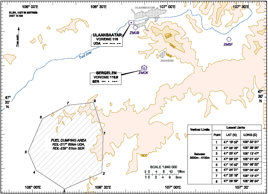
| 1 | Designation and lateral limits | BUYANT-UKHAA CTR 474556N 1064025E - 475659N 1062516E - 480417N 1063703E - 474703N 1070033E - 474326N 1065439E - 474556N 1064025E |
| 2 | Vertical limits |
GND-2100m AMSL |
| 3 | Airspace classification | C |
| 4 | ATS unit call sign Language(s) |
Buyant-Ukhaa tower Mongolian, English |
| 5 | Transition altitude |
3900m |
| 6 | Hours of applicability (or activation) | NIL |
| 7 | Remarks |
NIL |
ZMUB AD 2.18 ATS communication facilities
| Service designation |
Call sign |
Frequency |
SATVOICE numbers | Logon address | Hours of operation |
Remarks |
|---|---|---|---|---|---|---|
| 1 | 2 | 3 | 4 | 5 | 6 | 7 |
APP |
Ulaanbaatar approach | 120.000 MHz |
NIL |
NIL |
H24 |
NIL |
TWR |
Buyant-Ukhaa tower | 132.700 MHz |
NIL |
NIL |
H24 |
NIL |
AFIS |
Artsat |
5715 kHz |
NIL |
NIL |
HJ |
NIL |
SAR |
UBRCC | 121.500 MHz 5680 kHz |
NIL |
NIL |
H24 |
NIL |
ATIS |
Buyant-Ukhaa INFO | 125.000 MHz |
NIL |
NIL |
H24 |
NIL |
ZMUB AD 2.19 Radio navigation and landing aids
| Type of aid, MAG VAR, Type of supported OPS (For VOR/ILS/MLS, give declination) |
ID |
Frequency |
Hours of operation |
Position of transmitting antenna coordinates |
Elevation of DME transmitting antenna |
Service volume radius from the GBAS reference point | Remarks |
|---|---|---|---|---|---|---|---|
| 1 | 2 | 3 | 4 | 5 | 6 | 7 | 8 |
VOR/DME (5°W/ 2020) |
UDA |
116.000 MHz 1194.00MHz CH 107X |
H24 |
475204.0N 1064401.0E |
1290 m |
NIL |
NIL |
NDB (5°W/ 2020) |
DA |
520 kHz |
H24 |
475242.9N 1064309.2E |
NIL |
NIL |
NIL |
NDB (5°W/ 2020) |
IM | 450 kHz | H24 | 475137.0N 1064437.1E |
NIL |
NIL |
NIL |
Outer marker |
NIL |
75 MHz |
H24 |
475244.3N 1064308.4E |
NIL |
NIL |
NIL |
Middle marker |
NIL |
75 MHz |
H24 |
475138.5N 1064436.2E |
NIL |
NIL |
NIL |
ILS 14 (5°W/ 2020) LOC |
IDA |
110.300 MHz |
H24 |
474946.8N 1064703.8E |
NIL |
NIL |
NIL |
ILS 14 (5°W/ 2020) GP |
NIL |
335.000 MHz |
H24 |
475101.0N 1064515.9E |
NIL |
NIL |
NIL |
ILS/DME |
IDA | 1001.00 MHz CH 40X |
H24 |
475100.6N 1064515.6E |
1290 m |
NIL |
NIL |
ZMUB AD 2.20 Local aerodrome regulations
1. LIMITATIONS ON USE OF AERODROME
ZMUB AD 2.21 Noise abatement procedures
NIL
ZMUB AD 2.22 Flight procedures
1. Visual flight procedure
Note:
-
When VFR flight is to land at aerodrome or fly over the aerodrome control zone at an altitude of 2100m or below, the pilot should make contact with the air traffic controller of control zone before passing the following points:
-
If flying in from the east, YARMAGIIN GUUR reporting point;
-
If flying in from the north, RASHAANT or NAIRAMDAL reporting point;
-
If flying in from the west or northwest, DOLOON KHUDAG and SONGINO reporting points;
-
-
Transfer of control of VFR flight operating at the altitude of 2100m or below between Buyant-Ukhaa and Chinggis Khaan aerodrome control zone is to be coordinated at ULZIIT and BUGAT reporting points.
-
ULZIIT and DOLOON KHUDAG reporting points are located close to aerodrome straight route before the Instrument approach procedure and missed approach procedure, therefore the following restrictions should be adhered to:
-
It is prohibited to use ULZIIT reporting point in the case where the time and the direction of an aircraft landing on RWY 14 coincides, unless otherwise approved by the air traffic control unit.
-
It is prohibited to use DOLOON KHUDAG reporting point in the case where the time and direction of an aircraft landing on RWY 14 and taking-off from RWY 32 coincides, unless otherwise approved by the air traffic control unit.
-
2. Instrument flight procedure
-
ENR 1.1, ENR 1.3 and ENR 1.7;
-
Instrument Approach Charts contained in AD 2-ZMUB-13-1, AD 2-ZMUB-13-3, AD 2-ZMUB-13-5, AD 2-ZMUB-13-7 and AD 2-ZMUB-13-9;
-
Standard Departure Charts contained in AD 2-ZMUB-9-1 and AD 2-ZMUB-9-3.
3. Landing
ZMUB AD 2.23 Additional information
1. Fuel dumping area
Information concerning the fuel dumping area of Buyant-Ukhaa international airport is shown below.
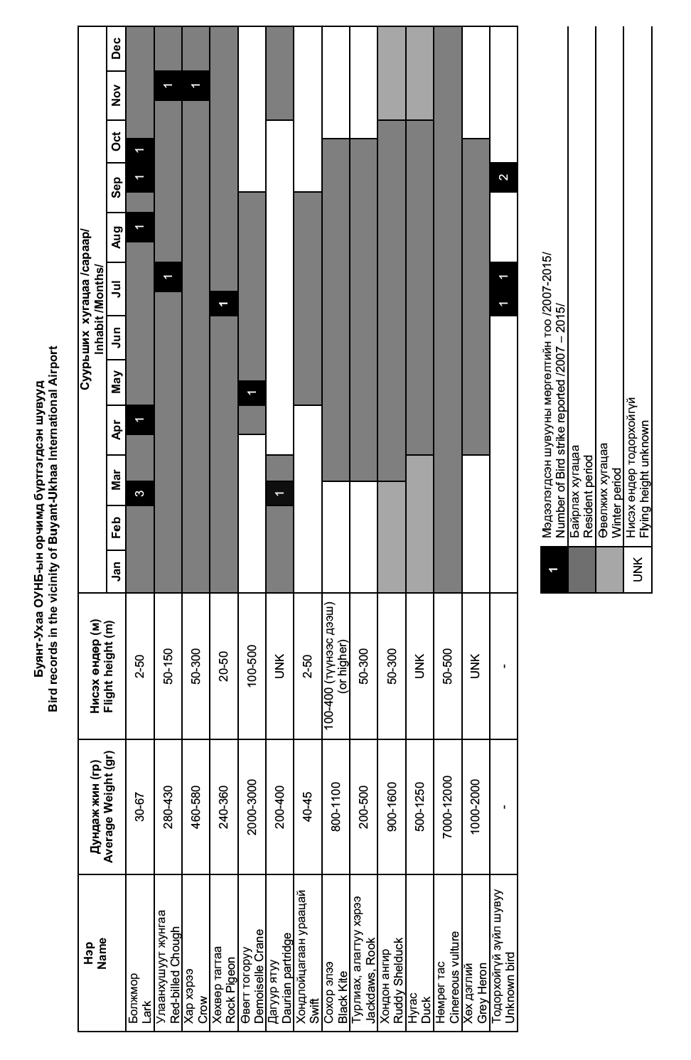
2. Bird concentrations in the vicinity of aerodrome
-
Occasionally 2 to 4 Demoiselle Cranes, 1 to 6 Red-billed Chough, 1 to 2 Carrion Crow and usually from November to March 2 to 8 (sometimes 8 to 12) Daurian Partridges are seen near the aerodromes.
-
Flying activity of Red-billed Choughs increases in windy condition.
-
Small Passerines such as Horned Larks, Mongolian Larks, Meadow Buntings are often see near the aerodrome during whole year. Their number increases (200-500) to spend the winter during the period less snow from October to March and usually fly at 2 to 50 metres.
-
Fork-tailed Swifts and Barn Swallows are seen in numbers 50 to 100 near the aerodrome between July and middle of August and usually fly 2 to 50 metres.
-
From May to July: Black Kites nests on aspen tree along the Tuul river valley and fly at 100 to 400 metres in numbers 3 to 20. From August to September highest number (700 to 1800) of black Kites is seen near Emeelt dumping area (Area 4), flying at 400 metres or more.
-
Waterfowls such as Rudy Shelducks, Ducks, Grey Herons are commonly seen near water ponds (Area 1,2 and 3) from April to the end of October. Approximately 100 ducks and more than 300 Rudy Shelducks spend the winter here.
-
Flocks of 10 to 20 Demoiselle Cranes occasionally fly near the aerodrome middle of August to beginning of September.
-
200 to 3000 Rooks and Jackdaws from September to October, 6-160 Ruddy Shelducks from October to November and 10-200 Crows from November to March fly at 50 to 300 metres along the river valley to west during morning sunrise and to east during evening sunset.
-
Red-Billed Choughs feed in the river valley in numbers 30 to 200 and usually fly at 50 to 150 metres.
-
Pigeons fly near the end of RWY 14 in number 3 to 10 sometimes even 20-30 during the morning sunrise and fly 20 to 50 metres.
ZMUB AD 2.24 Charts related to aerodrome
|
|
Page |
|---|---|
Aerodrome Chart-ICAO |
AD 2-ZMUB-2-1 |
Aircraft Parking/Docking Chart-ICAO |
AD 2-ZMUB-3-1 |
Standard Departure Chart-Instrument (SID)-ICAO (VOR/DME RWY 32 TATIG 3E, TOROV 3E/3F, SER 2F, DUKIM 3E, LUBSO 3E) |
AD 2-ZMUB-9-1 |
Conversion table (SID) (VOR/DME RWY 32 TATIG 3E, TOROV 3E/3F, SER 2F, DUKIM 3E, LUBSO 3E) |
AD 2-ZMUB-9-2 |
Standard Departure Chart-Instrument (SID)-ICAO (NDB RWY 32 TATIG 3G, TOROV 4G/3H, SER 1B, DUKIM 3G, LUBSO 4G) |
AD 2-ZMUB-9-3 |
Conversion table (SID) (NDB RWY 32 TATIG 3G, TOROV 4G/3H, SER 1B, DUKIM 3G, LUBSO 4G) |
AD 2-ZMUB-9-4 |
Instrument Approach Chart-ICAO (VOR/DME RWY 14 ACFT CAT A/B, C/D) |
AD 2-ZMUB-13-1 |
Conversion table (VOR/DME RWY 14 ACFT CAT A/B, C/D) |
AD 2-ZMUB-13-2 |
Instrument Approach Chart-ICAO (NDB RWY 14 ACFT CAT A/B, C/D) |
AD 2-ZMUB-13-3 |
Conversion table (NDB RWY 14 ACFT CAT A/B, C/D) |
AD 2-ZMUB-13-4 |
Instrument Approach Chart-ICAO (NDB/DME RWY 14 ACFT CAT A/B, C/D) |
AD 2-ZMUB-13-5 |
Conversion table (NDB/DME RWY 14 ACFT CAT A/B, C/D) |
AD 2-ZMUB-13-6 |
Instrument Approach Chart-ICAO (ILS RWY 14 ACFT CAT A/B, C/D) |
AD 2-ZMUB-13-7 |
Conversion table (ILS RWY 14 ACFT CAT A/B, C/D) |
AD 2-ZMUB-13-8 |
Instrument Approach Chart-ICAO (RNP RWY 14 (LNAV only) ACFT CAT A/B/C/D) |
AD 2-ZMUB-13-9 |
Aeronautical Data Tabulation (RNP RWY 14 (LNAV only) ACFT CAT A/B/C/D) |
AD 2-ZMUB-13-10 |
Visual Reporting Points Chart (Visual REP) |
AD 2-ZMUB-14-1 |
Bird concentrations in the vicinity of aerodrome |
AD 2-ZMUB-15-1 |