ZMAT — GOBI-ALTAI/Altai
ZMAT AD 2.1 Aerodrome location indicator and name
ZMAT — GOBI-ALTAI/Altai
ZMAT AD 2.2 Aerodrome geographical and administrative data
| 1 | ARP coordinates and site at AD | 462237N 0961302E
104°, 1450m from THR 10 of paved RWY |
| 2 | Direction and distance from (city) | 280°, 2.6km from town (Yesunbulag) |
| 3 | Elevation/Reference temperature/Mean low temperature | 2219 m / 22.5°C / -29.5°C |
| 4 | Geoid undulation at AD ELEV PSN | NIL |
| 5 | MAG VAR/Annual change | 0°(2020)/5.9'W |
| 6 | Name of AD operator, address, TEL and telefax numbers, e-mail address, AFS address and, if available, website address |
National Civil Aviation Center SOLLC Tel: 976-71281200 976-71286127 976-70483544 Fax: 976-70484044 AFS: ZMATZTZX E-mail: govi-altai.airport@ncac.mn |
| 7 | Types of traffic permitted (IFR/VFR) |
IFR/VFR |
| 8 | Remarks | Reference code: 3C |
ZMAT AD 2.3 Operational hours
| 1 | Aerodrome operator | 00:00-09:00 UTC MON-FRI |
| 2 | Customs and immigration | NIL |
| 3 | Health and sanitation | NIL |
| 4 | AIS Briefing Office | NIL |
| 5 | ATS Reporting Office | HO |
| 6 | MET Briefing Office | HO |
| 7 | Air Traffic Service |
HO |
| 8 | Fuelling | HO |
| 9 | Handling | HO |
| 10 | Security | H24 |
| 11 | De-icing | NIL |
| 12 | Remarks | NIL |
ZMAT AD 2.4 Handling services and facilities
| 1 | Cargo-handling facilities | NIL |
| 2 | Fuel/oil types | Fuel: TS-1 Oil: NIL |
| 3 | Fuelling facilities/capacity | 1 truck, 7.5t, 8.3L/s |
| 4 | De-icing facilities | NIL |
| 5 | Hangar space for visiting aircraft |
NIL |
| 6 | Repair facilities for visiting aircraft | NIL |
| 7 | Remarks |
NIL |
ZMAT AD 2.5 Passenger facilities
| 1 | Hotels | In downtown |
| 2 | Restaurants | In downtown |
| 3 | Transportation | Taxi |
| 4 | Medical facilities | In downtown |
| 5 | Bank and Post Office | In downtown |
| 6 | Tourist Office |
In downtown |
| 7 | Remarks |
NIL |
ZMAT AD 2.6 Rescue and firefighting services
| 1 | AD category for firefighting | CAT 4 |
| 2 | Rescue equipment | Firefighting truck: 1 Capacity of water: 8t Discharge rate foam solution: 5300L/min Capacity of foam: 400L |
| 3 | Capability for removal of disabled aircraft |
Available. (Type of aircraft up to CRJ7) Contact number: 976-71281200Available. (Type of aircraft up to CRJ7) |
| 4 | Remarks | Emergency management agency of Govi-Altai aimag provided under contract.Total staff has 8 personnel. |
ZMAT AD 2.7 Seasonal availability-clearing
| 1 | Types of clearing equipment | Snow sweeper truck: 2 |
| 2 | Clearance priorities | RWY, TWY, Apron |
| 3 | Remarks | NIL |
ZMAT AD 2.8 Aprons, taxiways and check locations/positions data
| 1 | Apron designation, surface and strength | Concrete, PCN 16/R/B/W/T |
| 2 | Taxiway designation, width, surface and strength | A - 15 m, asphalt, PCN 25/F/A/Y/T 1 - 15 m, gravel, CBR 66 |
| 3 | Altimeter checkpoint location and elevation | THR 10/ 2219m |
| 4 | VOR checkpoints | NIL |
| 5 | INS checkpoints | NIL |
| 6 | Remarks | NIL |
ZMAT AD 2.9 Surface movement guidance and control system and markings
| 1 | Use of aircraft stand ID signs, TWY guide lines and visual docking/parking guidance system of aircraft stands |
TWY guide lines and aircraft stand sign at apron. |
| 2 | RWY and TWY markings and LGT | RWY markings: Designation, THR, TDZ, aiming point, centre line, edge RWY lights: THR, edge, end TWY markings: Edge, centre line, holding position TWY lights: Edge |
| 3 | Stop bars and RWY guard lights | NIL |
| 4 | Other RWY protection measures | NIL |
| 5 | Remarks | NIL |
ZMAT AD 2.10 Aerodrome obstacles
1. Area 2 obstacles
For Area 2 obstacles, please use the following link:
https://ais.mn/files/aip/eAIP/AREA2/ZMATAREA2_1225.xlsx
2. Area 3 obstacles
For Area 3 obstacles, please use the following link:
https://ais.mn/files/aip/eAIP/AREA3/ZMATAREA3_0724.xlsx
ZMAT AD 2.11 Meteorological information provided
| 1 | Associated MET Office | Meteorology, hydrology and environmental monitoring center of Gobi-Altai aimag |
| 2 | Hours of service MET Office outside hours |
HO |
| 3 | Office responsible for TAF preparation Periods of validity |
Meteorology, hydrology and environmental monitoring center of Gobi-Altai aimag 9h |
| 4 | Trend forecast Interval of issuance |
TREND 2h |
| 5 | Briefing/consultation provided |
Personal consultation, telephone, closed curcuit television, other devices, self-briefing display |
| 6 | Flight documentation Language(s) used |
Charts, tabular forms, abbreviated plain language text Mongolian, English |
| 7 | Charts and other information available for briefing or consultation |
Surface and upper air analysis charts, prognostic charts, significant weather charts, upper Winds/Temperatures charts, Aviation Weather Observation System real time data |
| 8 | Supplementary equipment available for providing information | Satellite data, products of World area forecast system |
| 9 | ATS units provided with information | TWR, APP |
| 10 | Climatological information |
Climatology |
| 11 | Additional information (limitation of service, etc.) |
AD, route, landing and take-off forecasts, AIRMET, AD WRNG Tel: 976-70483093 Tel: 976-95876338 |
ZMAT AD 2.12 Runway physical characteristics
| Designations RWY NR |
TRUE BRG |
Dimensions of RWY (m) |
Strength of the PCN and surface of RWY and SWY | THR coordinates RWY end coordinates THR geoid undulation |
THR elevation and highest elevation of TDZ of precision APCH RWY | Slope of RWY-SWY |
|---|---|---|---|---|---|---|
| 1 | 2 | 3 | 4 | 5 | 6 | 7 |
10 |
103.89° |
2899 x 30 |
PCN 33 /F /A /Y /T asphalt |
462248.53N 0961155.86E |
THR: 2219m TDZ: 2217m |
RWY: 1.13% |
28 |
283.92° |
2899 x 30 |
PCN 33 /F /A /Y /T asphalt |
462225.97N 0961407.55E |
THR: 2186m TDZ: 2190m |
RWY: 1.13% |
10 |
103.87° |
2300 x 35 |
CBR 68 gravel |
462239.40N 0961221.55E |
THR: 2218m |
RWY: 1.31% |
28 |
283.89° |
2300 x 35 |
CBR 68 gravel |
462221.54N 0961406.01E |
THR: 2188m |
RWY: 1.31% |
| SWY dimensions (m) |
CWY dimensions (m) | Strip dimensions (m) | Dimensions of runway end safety areas (m) | Location and description of arresting system | OFZ | Remarks |
|---|---|---|---|---|---|---|
| 8 | 9 | 10 | 11 | 12 | 13 | 14 |
NIL |
NIL |
3020 x 150 |
120 x 60 |
NIL |
NIL |
NIL |
NIL |
NIL |
3020 x 150 |
90 x 60 |
NIL |
NIL |
NIL |
NIL |
NIL |
2420 x 150 |
90 x 70 |
NIL |
NIL |
NIL |
NIL |
NIL |
2420 x 150 |
90 x 70 |
NIL |
NIL |
NIL |
ZMAT AD 2.13 Declared distances
| RWY Designator |
TORA (m) |
TODA (m) |
ASDA (m) |
LDA (m) | Remarks |
|---|---|---|---|---|---|
| 1 | 2 | 3 | 4 | 5 | 6 |
10 |
2899 | 2899 |
2899 | 2899 |
NIL |
28 |
2899 |
2899 |
2899 | 2899 |
NIL |
10 |
2300 | 2300 |
2300 | 2300 |
NIL |
28 |
2300 |
2300 |
2300 | 2300 |
NIL |
ZMAT AD 2.14 Approach and runway lighting
| RWY Designator |
APCH LGT type, LEN, INTST |
THR LGT colour, WBAR |
VASIS (MEHT) PAPI |
TDZ LGT LEN |
|---|---|---|---|---|
| 1 | 2 | 3 | 4 | 5 |
10 |
NIL |
NIL |
NIL |
NIL |
28 |
SALS 420 m LIM |
green |
PAPI 3° Left (15m) |
NIL |
| RCLL LEN, spacing, colour, INTST |
REDL LEN, spacing, colour, INTST |
RENL colour, WBAR |
STWL LEN (m), colour |
Remarks |
|---|---|---|---|---|
| 6 | 7 | 8 | 9 | 10 |
NIL |
2900m 60m white 2300-2900m white-yellow LIM |
red |
NIL |
NIL |
NIL |
2900m 60m white 2300-2900m white-yellow LIM |
red |
NIL |
NIL |
ZMAT AD 2.15 Other lighting, secondary power supply
| 1 | ABN/IBN location, characteristics and hours of operation | NIL |
| 2 | LDI location and LGT Anemometer location and LGT |
Shown on AD chart Not LGTD, 90m from THR 10 LGTD, 100m from THR 28 |
| 3 | TWY edge lights, centre line lights and stop bars (if any) | Edge: TWY-A |
| 4 | Secondary power supply/switch-over time | Secondary power supply to all lighting at AD Switch-over time: 15s |
| 5 | Remarks | NIL |
ZMAT AD 2.16 Helicopter landing area
| 1 | Coordinates TLOF or THR of FATO Geoid undulation |
NIL |
| 2 | TLOF and/or FATO elevation (m) | NIL |
| 3 | TLOF and FATO area dimensions, surface, strength, marking | NIL |
| 4 | True BRG of FATO | NIL |
| 5 | Declared distance available | NIL |
| 6 | APCH and FATO lighting | NIL |
| 7 | Remarks | NIL |
ZMAT AD 2.17 ATS airspace
| 1 | Designation and lateral limits | ALTAI CTR A circle, radius 20km centred at 462237N 0961302E (ARP) |
| 2 | Vertical limits |
GND-3150m AMSL |
| 3 | Airspace classification | D |
| 4 | ATS unit call sign Language(s) |
Taishir approach Mongolian |
| 5 | Transition altitude |
3900m |
| 6 | Hours of applicability (or activation) | NIL |
| 7 | Remarks |
NIL |
ZMAT AD 2.18 ATS communication facilities
| Service designation |
Call sign |
Frequency |
SATVOICE numbers | Logon address | Hours of operation |
Remarks |
|---|---|---|---|---|---|---|
| 1 | 2 | 3 | 4 | 5 | 6 | 7 |
APP |
Taishir approach |
130.000 MHz |
NIL |
NIL |
HO |
NIL |
AFIS |
|
5715 kHz |
NIL |
NIL |
HO |
NIL |
ZMAT AD 2.19 Radio navigation and landing aids
| Type of aid, MAG VAR, Type of supported OPS (For VOR/ILS/MLS, give declination) |
ID |
Frequency |
Hours of operation |
Position of transmitting antenna coordinates |
Elevation of DME transmitting antenna |
Service volume radius from the GBAS reference point | Remarks |
|---|---|---|---|---|---|---|---|
| 1 | 2 | 3 | 4 | 5 | 6 | 7 | 8 |
VOR/DME (0°/2020) |
VGA |
116.400 MHz 1198.00MHz CH 111X |
HO |
462242.4N 0961256.6E |
2220 m |
NIL |
NIL |
ZMAT AD 2.20 Local aerodrome regulations
NIL
ZMAT AD 2.21 Noise abatement procedures
NIL
ZMAT AD 2.22 Flight procedures
1. Visual flight procedure
2. Instrument flight procedure
-
ENR 1.1, ENR 1.3 and ENR 1.7;
-
Standard Instrument Departure Chart contained in AD 2-ZMAT-9-1;
-
Instrument Approach Charts contained in AD 2-ZMAT-13-1, AD 2-ZMAT-13-3 and AD 2-ZMAT-13-5;
3. Take-off
ZMAT AD 2.23 Additional information
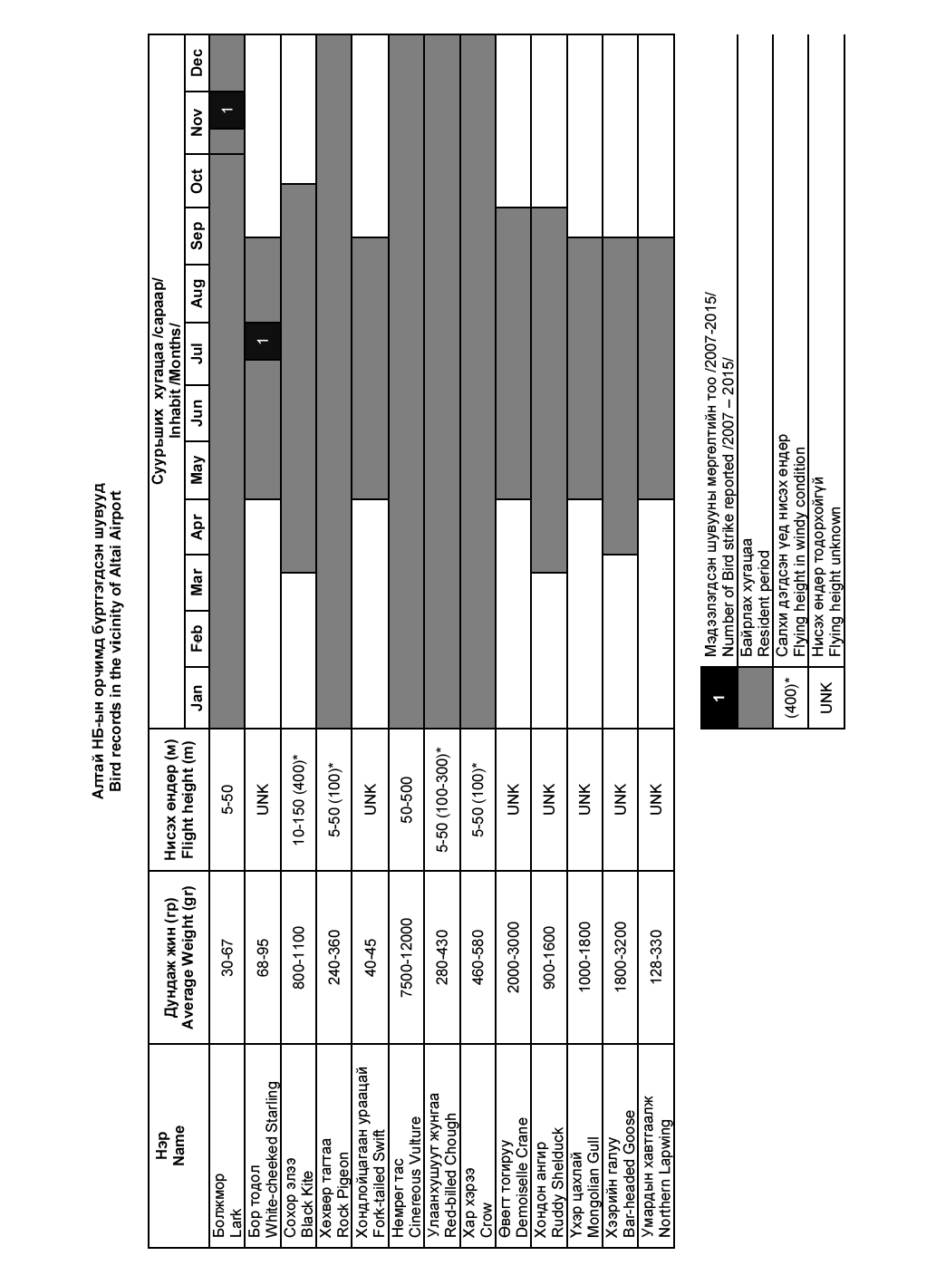
1. Bird concentrations in the vicinity of aerodrome
ZMAT AD 2.24 Charts related to aerodrome
| Page |
|
|---|---|
Aerodrome Chart-ICAO |
AD 2-ZMAT-2-1 |
Aerodrome Chart-ICAO |
AD 2-ZMAT-2-2 |
Aerodrome obstacle chart – ICAO Type A (Operating Limitations) |
AD 2-ZMAT-5-1 |
Standard Departure Chart-Instrument (SID)-ICAO (RWY 10 BH 1A, IGOMA 2A, ODOKU 2A ACFT CAT B/C) |
AD 2-ZMAT-9-1 |
Conversion table (SID)-ICAO (RWY 10 BH 1A, IGOMA 2A, ODOKU 2A ACFT CAT B/C) |
AD 2-ZMAT-9-2 |
Instrument Approach Chart-ICAO (VOR Z RWY 28 ACFT CAT B) |
AD 2-ZMAT-13-1 |
Conversion table (VOR Z RWY 28 ACFT CAT B) |
AD 2-ZMAT-13-2 |
Instrument Approach Chart-ICAO (VOR Y RWY 28 ACFT CAT B/C) |
AD 2-ZMAT-13-3 |
Conversion table (VOR Y RWY 28 ACFT CAT B/C) |
AD 2-ZMAT-13-4 |
Instrument Approach Chart-ICAO (RNP RWY 28 (LNAV only) ACFT CAT B/C) |
AD 2-ZMAT-13-5 |
Aeronautical Data Tabulation (RNP RWY 28 (LNAV only) ACFT CAT B/C) |
AD 2-ZMAT-13-6 |
Bird concentrations in the vicinity of aerodrome |
AD 2-ZMAT-15-1 |